 Filter: Categories of Wisconsin Historical Images
Filter: Subject of Agriculture
Filter: Subject of human settlements
Filter: Subject of ships
Filter: Categories of Wisconsin Historical Images
Filter: Subject of Agriculture
Filter: Subject of human settlements
Filter: Subject of ships

| Date: | 1886 |
|---|---|
| Description: | Cover of an advertising brochure for the Milwaukee Harvester Company featuring a color chromolithograph illustration of a farmer in a field operating a hor... |

| Date: | 1874 |
|---|---|
| Description: | Bird's-eye map of Chippewa Falls. |
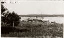
| Date: | 1925 |
|---|---|
| Description: | Washington Island, including field and fence, with buildings, automobiles, and a large ship in the distance. |
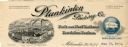
| Date: | |
|---|---|
| Description: | Memohead of the Plankinton Packing Company, a pork and beef packer and provision dealer in Milwaukee, Wisconsin. Includes an elevated view of the company b... |

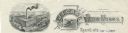
| Date: | |
|---|---|
| Description: | Letterhead of the Chilton Branch of the Falk Jung & Borchert Brewing Company, headquartered in Milwaukee, Wisconsin. It includes, on the left, an elevated ... |
| Date: | |
|---|---|
| Description: | Memohead of the J.I. Case Plow Works of Racine, Wisconsin, with an elevated view of the company plant and a smaller scene set on a scroll of a man driving ... |
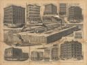
| Date: | 1871 |
|---|---|
| Description: | Collage depicting multiple McCormick buildings reconstructed or built after the Chicago Fire. The caption at bottom reads, "Rebuilt Chicago. — Buildings Er... |
| Date: | |
|---|---|
| Description: | The world is flat; we get around this stretched credulity by going straight as an arrow and meeting ourselves in a space of time |
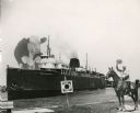
| Date: | |
|---|---|
| Description: | Composite photograph in the "Tall Tale" style. An enormous bovine stands on the front deck of the Pere Marquette 21, a steamer. On the right, on the... |
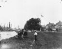
| Date: | 1900 |
|---|---|
| Description: | View from rear of a man using a horse-drawn mower along a shoreline at League Island. A man is standing near him on the right. In the background on the lef... |

| Date: | 03 1777 |
|---|---|
| Description: | Map showing the British and Hessian attack on Fort Washington in November of 1776. The movements and fortifications of the British and Hessian troops appea... |

| Date: | 1755 |
|---|---|
| Description: | Map of Virginia and parts of Maryland, North Carolina, and New Jersey. It shows borders, boundary lines, some Native American land, counties, cities, towns... |
If you didn't find the material you searched for, our Library Reference Staff can help.
Call our reference desk at 608-264-6535 or email us at: