Filter: Categories of Wisconsin Historical Images
Filter: Subject of Agriculture
Filter: Subject of human settlements
Filter: Subject of lakes
Filter: Categories of Wisconsin Historical Images
Filter: Subject of Agriculture
Filter: Subject of human settlements
Filter: Subject of lakes
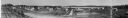
| Date: | 1916 |
|---|---|
| Description: | Panoramic view of the Wingra area from the railroad tracks north of Gregory Street. Looking towards Lake Wingra, across Monroe Street. |

| Date: | 1950 |
|---|---|
| Description: | Aerial view of the Frank Lloyd-Wright-dsigned Unitarian Church under construction and the Veteran's Administration Hospital, also under construction, to th... |
| Date: | 1926 |
|---|---|
| Description: | Elevated view of Picnic Point on Lake Mendota from the University of Wisconsin-Madison Soils building. |
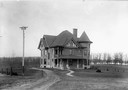
| Date: | 1900 |
|---|---|
| Description: | View of the University of Wisconsin residence of William Arnon Henry, Dean of Agriculture, 10 Babcock Drive with Lake Mendota in the background. |
| Date: | 1875 |
|---|---|
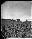
| Description: | View from Southeast shore of Lake Monona across a cornfield, perhaps on the farm of Thomas Williamson. |

| Date: | 1874 |
|---|---|
| Description: | Distant view of the town from a hill with houses, garden plots, businesses and churches. |
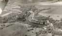
| Date: | |
|---|---|
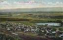
| Description: | Elevated view of Cochrane and the surrounding landscape. There are houses, railroad tracks, distant fields, a pond and some irrigation canals. Caption read... |

| Date: | 1905 |
|---|---|
| Description: | View across field and fence downhill towards the town of Fish Creek and the bay. Caption reads: "Greetings from Fish Creek, Wis." |

| Date: | 1930 |
|---|---|
| Description: | Aerial view above Shorewood Hills near Madison, looking northeast. |
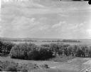
| Date: | |
|---|---|
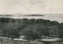
| Description: | Picnic Point from University drive, currently known as Observatory Hill. There are orchards in the foreground. |

| Date: | 1957 |
|---|---|
| Description: | Aerial view of Yellowstone Lake and surrounding countryside. |

| Date: | 1930 |
|---|---|
| Description: | Aerial view of near west side, including West High School, the Forest Products Laboratory, Lake Mendota, and Picnic Point. |

| Date: | 1909 |
|---|---|
| Description: | View from the University of Wisconsin service building smokestack of south Madison, including Mills Street, Mound Street, and the Greenbush. Lake Monona is... |
| Date: | 1905 |
|---|---|
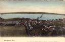
| Description: | Elevated view of Stockholm and Lake Pepin. Caption reads: "Stockholm, Wis." |
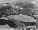
| Date: | 1965 |
|---|---|
| Description: | Aerial view looking west-northwest over Silver Lake. |

| Date: | 1855 |
|---|---|
| Description: | Map reads "Our Country" which is accompanied by a sailor with a flag to the left and workers rejoicing under the Constitution and Laws to the right. Across... |
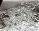
| Date: | 09 1958 |
|---|---|
| Description: | Aerial view of University Farms neighborhood near Lake Mendota. |
If you didn't find the material you searched for, our Library Reference Staff can help.
Call our reference desk at 608-264-6535 or email us at: