 Filter: Categories of Wisconsin Historical Images
Filter: Subject of Agriculture
Filter: Subject of barracks
Filter: Categories of Wisconsin Historical Images
Filter: Subject of Agriculture
Filter: Subject of barracks

| Date: | 1967 |
|---|---|
| Description: | A man is using an International Harvester tractor to level land before building barracks in Vietnam. |

| Date: | 1816 |
|---|---|
| Description: | This is a photostat copy of a manuscript map in the National Archives showing a plan of Fort Howard and a view of its north side. Originally surveyed by Wi... |
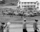
| Date: | 1967 |
|---|---|
| Description: | Men are walking in the foreground. In the background more men, in uniform, stand near several International Payscrapers parked in Phan Rang, Vietnam. Recen... |

| Date: | 03 1777 |
|---|---|
| Description: | Map showing the British and Hessian attack on Fort Washington in November of 1776. The movements and fortifications of the British and Hessian troops appea... |
If you didn't find the material you searched for, our Library Reference Staff can help.
Call our reference desk at 608-264-6535 or email us at: