 Filter: Categories of Wisconsin Historical Images
Filter: Subject of Aerial photographs
Filter: County of Dane
Filter: Categories of Wisconsin Historical Images
Filter: Subject of Aerial photographs
Filter: County of Dane

| Date: | |
|---|---|
| Description: | Aerial view of the town of McFarland, with Lake Waubesa in the background. |
| Date: | 1962 |
|---|---|
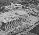
| Description: | Aerial view of the Hill Farms State Office Building, 4802 Sheboygan Avenue, during construction. |
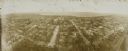
| Date: | 1908 |
|---|---|
| Description: | Kite aerial panoramic photograph of the central business district. In the distance is Lake Mendota. The fire damaged Wisconsin State Capitol is in the cent... |
| Date: | 1968 |
|---|---|
| Description: | Aerial view of the UW Campus and Lake Mendota. Memorial Library, Historical Society, and Red Gym in the center. |

| Date: | 1919 |
|---|---|
| Description: | Aerial view of the Isthmus and Lake Mendota from over Lake Monona. The Wisconsin State Capitol is in the center. |

| Date: | |
|---|---|
| Description: | Text on reverse reads: "View of downtown Madison and Capitol Square from the air. In the foreground are Law Park and Lake Monona, in the background Lake Me... |

| Date: | |
|---|---|
| Description: | Aerial view of the Isthmus from over Lake Monona. The Wisconsin State Capitol and Lake Mendota are in the background. In the foreground is John Nolen Drive... |

| Date: | 1942 |
|---|---|
| Description: | Aerial view of Capitol Square with Lake Monona in the foreground and Lake Mendota in the background. Pinckney Street is on the right. |

| Date: | |
|---|---|
| Description: | Hand-colored aerial view of the Capitol from West Washington Avenue. Lake Monona on the right. The Belmont Hotel, Gay Building and Loraine Hotel can be see... |

| Date: | 1923 |
|---|---|
| Description: | Aerial view of Capitol Square and surrounding area from East Washington Avenue. The old water tower in the center. Lake Monona is on the left; Lake Mendota... |

| Date: | |
|---|---|
| Description: | Aerial view of Capitol Square from above King Street. Caption reads: "Aeroplane View of State Capitol, Madison, Wis." Text on reverse reads: "Constructi... |

| Date: | 1980 |
|---|---|
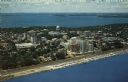
| Description: | Aerial view of Capitol Square and the surrounding central isthmus. Lake Monona is on the right. |
| Date: | |
|---|---|
| Description: | Color aerial postcard of the Isthmus from over Lake Monona. John Nolen Drive is along the shoreline in the foreground. The Wisconsin State Capitol is in th... |

| Date: | 1968 |
|---|---|
| Description: | Aerial view looking southwest, with Lake Mendota at right and East Gorham Street running from the bottom left corner. Lincoln School is in the foreground, ... |

| Date: | 1960 |
|---|---|
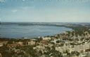
| Description: | Air view of the Lake Mendota Shore looking east. The Edgewater Hotel and Kennedy Manor are at bottom center with Lake Mendota at left. James Madison Park i... |

| Date: | 1962 |
|---|---|
| Description: | Air view in winter of the Triangle Redevelopment Project looking east with Regent Street running along the left edge, W. Washington Avenue along the top, a... |

| Date: | 06 1960 |
|---|---|
| Description: | Aerial view looking northwest showing an area to be redeveloped into high-rise dormitories. Lake Mendota and Bascom Woods can be seen at the top. Universit... |

| Date: | 03 1962 |
|---|---|
| Description: | Aerial view with beginning of construction on Sellery Hall on the block bounded by Park, West Johnson, Murray, and West Dayton Streets. Park Street runs fr... |

| Date: | 1965 |
|---|---|
| Description: | Air view of the west end of University of Wisconsin-Madison campus with U.W. Hospital and U.W. athletic fields at top. Campus Drive and University Avenue r... |

| Date: | 1968 |
|---|---|
| Description: | Air view of the University of Wisconsin-Madison campus looking north to Lake Mendota. Picnic Point, currently part of the Lakeshore Nature Preserve, and Ca... |
If you didn't find the material you searched for, our Library Reference Staff can help.
Call our reference desk at 608-264-6535 or email us at: