 Filter: Categories of Wisconsin Historical Images
Filter: Subject of Aerial photographs
Filter: County of Dane
Filter: Subject of automobiles
Filter: Categories of Wisconsin Historical Images
Filter: Subject of Aerial photographs
Filter: County of Dane
Filter: Subject of automobiles

| Date: | 1956 |
|---|---|
| Description: | Aerial view of the Chicago, Milwaukee, and St. Paul Railroad station, roundhouse, and yard at the intersection of West Washington Avenue (across lower left... |

| Date: | |
|---|---|
| Description: | Aerial view of a crowd at the Pennco Field (Royal Airport), gathered for an aerial show. Biplanes possibly used for the show are on the airstrip. Automob... |

| Date: | 1930 |
|---|---|
| Description: | Aerial view of the Pennco Field (Royal Airport) hanger surrounded by spectators gathered for an air show. Biplanes are parked on the grounds of the airpor... |
| Date: | 1933 |
|---|---|
| Description: | Aerial view of the Forest Products Laboratory, built in 1932. |

| Date: | |
|---|---|
| Description: | Aerial view of a full Camp Randall Stadium during half-time of a football game. The band is on the field in formation to spell "UW." |

| Date: | 05 05 1947 |
|---|---|
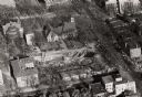
| Description: | Aerial view of the intersection of Pinckney, Main, and King Streets on the Madison Capitol Square. Kresge's, 27 East Main Street, can be seen at the upper ... |

| Date: | 05 05 1947 |
|---|---|
| Description: | Aerial view of Main, King, and Pinckney Streets intersection on Madison's Capitol Square. View is looking south down Pinckney Street. Kresge's, 27 East Mai... |

| Date: | 1956 |
|---|---|
| Description: | Aerial view of the Sears-Roebuck department store on East Washington Avenue and its surrounding parking lots. |

| Date: | 06 05 1951 |
|---|---|
| Description: | Aerial view of the Sherman Terrace Apartments and surrounding area. |

| Date: | 1958 |
|---|---|
| Description: | An aerial view of the construction of a new wing on a state office building. Automobiles are parked in a log along Lake Monona. |

| Date: | 1959 |
|---|---|
| Description: | Elevated view looking east from shoreline of Lake Monona towards Monona shoreline. There is a road, railroad tracks, and a rocky beach area with parked au... |
| Date: | 1958 |
|---|---|
| Description: | Aerial view of Chadbourne Hall under construction on the University of Wisconsin-Madison campus at the corner of Park Street and University Avenue. Music H... |

| Date: | 1956 |
|---|---|
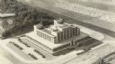
| Description: | Aerial view of Wisconsin General Hospital. |

| Date: | 1960 |
|---|---|
| Description: | Aerial view of the Dane County Hospital, looking west. Excavating for a more modern east wing that was finished in 1960 can be seen near the main building.... |

| Date: | 1960 |
|---|---|
| Description: | Aerial view of the Dane County Hospital, looking north. Excavating for a more modern east wing that was finished in 1960 can be seen. It had been called t... |

| Date: | 1959 |
|---|---|
| Description: | Aerial view of the Westgate Shopping Center under construction. |

| Date: | |
|---|---|
| Description: | Aerial view of Vieth's Park subdivision on the north shore of Lake Mendota. |

| Date: | 1954 |
|---|---|
| Description: | Aerial view of the west side of Madison showing newly constructed homes and homes under construction featured in the Parade of Homes. The main road through... |

| Date: | 01 15 1964 |
|---|---|
| Description: | Aerial photograph of the intersection of Mifflin, Pinckney, and Hamilton streets on Madison's Capitol Square. The Madison Hotel, 108 North Pinckney Street,... |

| Date: | 01 31 1964 |
|---|---|
| Description: | Aerial view of University Hill Farms area which has grown from a cow pasture to a square-mile housing and business area. 4,000 people live in 750 single-fa... |
If you didn't find the material you searched for, our Library Reference Staff can help.
Call our reference desk at 608-264-6535 or email us at: