 Filter: Categories of Wisconsin Historical Images
Filter: Subject of Aerial photographs
Filter: Community of Madison
Filter: Subject of aerial photographs
Filter: Type of Postcard
Filter: Categories of Wisconsin Historical Images
Filter: Subject of Aerial photographs
Filter: Community of Madison
Filter: Subject of aerial photographs
Filter: Type of Postcard
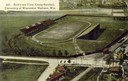
| Date: | 1908 |
|---|---|
| Description: | Colorized aerial view of Camp Randall Stadium at the University of Wisconsin-Madison. |
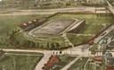
| Date: | 1908 |
|---|---|
| Description: | Aerial view of Camp Randall Stadium on the University of Wisconsin-Madison campus. Top image on Place File card. Caption reads: "Bird's-eye View, Camp Ra... |
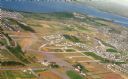
| Date: | 09 1958 |
|---|---|
| Description: | An aerial view of University Hill Farms on Madison's west side, a complete 604 acre community developed by the Regents of the University of Wisconsin. Real... |
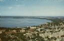
| Date: | 1968 |
|---|---|
| Description: | Aerial view of the UW Campus and Lake Mendota. Memorial Library, Historical Society, and Red Gym in the center. |

| Date: | 1919 |
|---|---|
| Description: | Aerial view of the Isthmus and Lake Mendota from over Lake Monona. The Wisconsin State Capitol is in the center. |

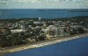
| Date: | |
|---|---|
| Description: | Text on reverse reads: "View of downtown Madison and Capitol Square from the air. In the foreground are Law Park and Lake Monona, in the background Lake Me... |

| Date: | |
|---|---|
| Description: | Aerial view of the Isthmus from over Lake Monona. The Wisconsin State Capitol and Lake Mendota are in the background. In the foreground is John Nolen Drive... |

| Date: | 1942 |
|---|---|
| Description: | Aerial view of Capitol Square with Lake Monona in the foreground and Lake Mendota in the background. Pinckney Street is on the right. |

| Date: | |
|---|---|
| Description: | Hand-colored aerial view of the Capitol from West Washington Avenue. Lake Monona on the right. The Belmont Hotel, Gay Building and Loraine Hotel can be see... |

| Date: | 1923 |
|---|---|
| Description: | Aerial view of Capitol Square and surrounding area from East Washington Avenue. The old water tower in the center. Lake Monona is on the left; Lake Mendota... |

| Date: | |
|---|---|
| Description: | Aerial view of Capitol Square from above King Street. Caption reads: "Aeroplane View of State Capitol, Madison, Wis." Text on reverse reads: "Constructi... |

| Date: | 1980 |
|---|---|
| Description: | Aerial view of Capitol Square and the surrounding central isthmus. Lake Monona is on the right. |
| Date: | |
|---|---|
| Description: | Color aerial postcard of the Isthmus from over Lake Monona. John Nolen Drive is along the shoreline in the foreground. The Wisconsin State Capitol is in th... |

| Date: | |
|---|---|
| Description: | Aerial view of the Oscar Mayer & Co. with Lake Mendota in the distance. Text on reverse reads: "Pictured here in aerial color view is the meat packing plan... |

| Date: | 1980 |
|---|---|
| Description: | Aerial shot directly over Picnic Point. Boats are in the lake. Text on reverse reads: "Picnic Point — A peninsula of the University of Wisconsin campus jut... |
| Date: | 1979 |
|---|---|
| Description: | Text on reverse reads: "Madison, Wisconsin photographed on infrared film at an altitude of 22 miles from a NASA research aircraft. Red = vegetation Blue ... |
If you didn't find the material you searched for, our Library Reference Staff can help.
Call our reference desk at 608-264-6535 or email us at: