 Filter: Categories of Wisconsin Historical Images
Filter: Subject of Aerial photographs
Filter: Creator Name of Unknown
Filter: Categories of Wisconsin Historical Images
Filter: Subject of Aerial photographs
Filter: Creator Name of Unknown
| Date: | |
|---|---|
| Description: | An aerial view of the White Mountains and Mount Washington, including a winding road. |

| Date: | |
|---|---|
| Description: | An aerial view of the port and a section of the city showing a large boat, a railway depot, a park plaza and a grid of city streets with large buildings. |

| Date: | |
|---|---|
| Description: | Aerial view of Dawson, Yukon Territory, Canada, from a surrounding hilltop, including a view of the distant hilltops and the adjacent Yukon river. Caption ... |
| Date: | |
|---|---|
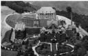
| Description: | The Villa Louis, also known as Dousman Mansion, in an aerial view. |

| Date: | |
|---|---|
| Description: | Aerial view of a developed strip of land on Barnegat Bay showing the Atlantic ocean, houses, lakes, railroad tracks, a marina and a jetty in the distance. |
| Date: | 1920 |
|---|---|
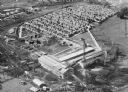
| Description: | Aerial view of the Baldwin Lumber Company, which sits next to a river. The main building consists of two long, rectangular structures that sit perpendicula... |
| Date: | 1950 |
|---|---|
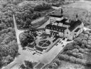
| Description: | An aerial view of the monastery, showing a complex of buildings, roads, and the surrounding tree-covered property. A walled garden is between the entrance ... |
| Date: | |
|---|---|
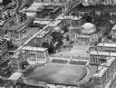
| Description: | An aerial view of the campus. Four main buildings comprise the campus, with smaller buildings standing on the right side. The larger buildings have round t... |
| Date: | |
|---|---|
| Description: | An aerial view of the campus and stadium. The stadium is in the foreground and steps lead up to several Pantheon-like buildings, including St. Paul's Chape... |
| Date: | |
|---|---|
| Description: | Aerial view of the campus, with the largest brick and stone buildings in the center. Trees border the structures and people are walking on paths or playing... |
| Date: | 10 23 1945 |
|---|---|
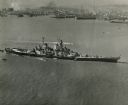
| Description: | Aerial view of U.S.S. Wisconsin (BB-64) in San Francisco Bay. Several boats can be seen in the water near the ship and San Francisco is visible in t... |

| Date: | |
|---|---|
| Description: | Aerial view of the Inn at Buck Hill Falls, built in 1901. A curving road leads to the main building, and several smaller outbuildings are nearby. |

| Date: | |
|---|---|
| Description: | Bird's eye view of Coney Island featuring the amusement park, shoreline, river, and a large boat. |

| Date: | 1960 |
|---|---|
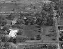
| Description: | Aerial view of the Dane County Hospital, looking west. Excavating for a more modern east wing that was finished in 1960 can be seen near the main building.... |

| Date: | 1960 |
|---|---|
| Description: | Aerial view of the Dane County Hospital, looking north. Excavating for a more modern east wing that was finished in 1960 can be seen. It had been called t... |

| Date: | 10 24 1946 |
|---|---|
| Description: | Photographic postcard of an aerial view of town. Text below reads: "Aerial View — Boscobel, Wis." |

| Date: | |
|---|---|
| Description: | Aerial view of Plymouth. Published by McLaughlin Aerial Surveys. |

| Date: | 04 12 1907 |
|---|---|
| Description: | Photographic postcard of an aerial view of town looking North. The Mississippi River is on the left. |

| Date: | 1964 |
|---|---|
| Description: | An aerial view of the U.S. Rubber Company plant and surrounding environment. |
| Date: | 05 22 1906 |
|---|---|
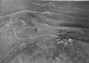
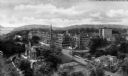
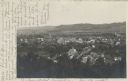
| Description: | Aerial view of the city and rolling hills in the background. A bridge crossing the Trempealeau River is also visible. |
If you didn't find the material you searched for, our Library Reference Staff can help.
Call our reference desk at 608-264-6535 or email us at: