Filter: Categories of Wisconsin Historical Images
Filter: FULL_DATE of 1990
Filter: Subject of human settlements
Filter: Subject of transportation
Filter: Categories of Wisconsin Historical Images
Filter: FULL_DATE of 1990
Filter: Subject of human settlements
Filter: Subject of transportation
| Date: | 1990 |
|---|---|
| Description: | Warehouse in Milwaukee's historic Third Ward transformed for its appearance in a made-for-TV movie as the Biograph Theatre in Chicago, where John Dillinger... |
| Date: | 1990 |
|---|---|
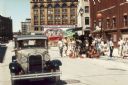
| Description: | Scene from the made-for-TV movie "Dillinger" shot in part on the streets of Milwaukee. A crowd is watching in the background. |
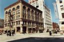
| Date: | 1990 |
|---|---|
| Description: | Building in Milwaukee's Third Ward as it appeared when portraying the Mason City Bank in the 1991 made-for-TV movie, "Dillinger". |
| Date: | 1990 |
|---|---|
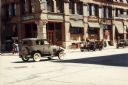
| Description: | Vintage automobiles on a Milwaukee Third Ward street used to represent a bank robbery in Mason City for the made-for-TV movie, "Dillinger". |
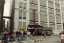
| Date: | 1990 |
|---|---|
| Description: | Film crew on street for "Dillinger," a made-for-TV movie shot in Milwaukee's Third Ward. |
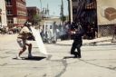
| Date: | 1990 |
|---|---|
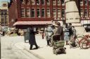
| Description: | Costumed actors on a Third Ward street transformed to represent the 1930s for the made-for-TV movie "Dillinger". |

| Date: | 1990 |
|---|---|
| Description: | "Tanknology" employee inspecting gasoline at "Cenex" gas station. |

| Date: | 1990 |
|---|---|
| Description: | A tourist map of Lafayette County, Wisconsin, that shows the locations of motels, camping, municipal parks, cheese factory tours, waysides, and golf course... |

| Date: | 1990 |
|---|---|
| Description: | This late 20th century tourist map of Sauk County, Wisconsin, shows the highways and roads, cities and towns, parks, airports, canoe landings, hospitals, s... |

| Date: | 1990 |
|---|---|
| Description: | This tourism brochure of Ashland County, Wisconsin, from the Ashland Area Chamber of Commerce includes a map of the county showing tourist destinations and... |

| Date: | 1990 |
|---|---|
| Description: | Map of bike routes in Madison. Lower right corner features a system map with legend. Upper left corner is an inset of the Capital Loop with labelled points... |
| Date: | 1990 |
|---|---|
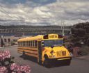
| Description: | Color photo of an International school bus with a man in the driver's seat. The bus is in the middle of a street in a hilly residential area, with landscap... |

| Date: | 1990 |
|---|---|
| Description: | This map shows the Minnesota Point, Wisconsin Point, Hog Island, Baker's Island, Connors Point, Blatnik Bridge, Superior Bay, Allouez Bay, the Nemadji Rive... |

| Date: | 1990 |
|---|---|
| Description: | This map shows various types of trails, boat landings, canoe areas, public beaches, picnic areas, campgrounds, golf courses, public tennis courts, and othe... |
| Date: | 1990 |
|---|---|
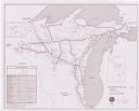
| Description: | This map shows Wisconsin Central Ltd. main track, lines out of service, abandoned lines, and trackage rights. The map covers Wisconsin and Michigan's upper... |

| Date: | 1990 |
|---|---|
| Description: | This map includes two insets: Plat of New Holstein village and Village of Chilton. The map also includes a table of statistics showing the assessed value o... |

| Date: | 1990 |
|---|---|
| Description: | This map, in addition to the Fort ground and buildings, shows owners of outbuildings, heights of buildings in stories, fences, roads, gardens, and cemetery... |
| Date: | 1990 |
|---|---|
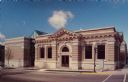
| Description: | Text on reverse reads: "Stoughton Public Library, Fourth and Main Streets, Stoughton, Wisconsin. The original Carnegie Free Library, constructed with $13,0... |
| Date: | 1990 |
|---|---|
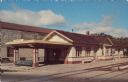
| Description: | Text on reverse reads: "C.M.ST.P. & P. Depot, Stoughton, Wisconsin. A Craftsman style structure built in 1913, it was abandoned by the railway in the 1970'... |
If you didn't find the material you searched for, our Library Reference Staff can help.
Call our reference desk at 608-264-6535 or email us at: