 Filter: Categories of Wisconsin Historical Images
Filter: FULL_DATE of 1975
Filter: Subject of transportation
Filter: Subject of human settlements
Filter: Categories of Wisconsin Historical Images
Filter: FULL_DATE of 1975
Filter: Subject of transportation
Filter: Subject of human settlements
| Date: | 1975 |
|---|---|
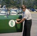
| Description: | Color photograph of an air pollution inspector wearing sunglasses is holding his badge near the door emblem on his International Scout II pickup. The truck... |
| Date: | 1975 |
|---|---|
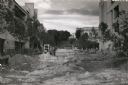
| Description: | View of the construction on the 700 and 800 blocks of State Street, looking west toward Bascom Hill. |

| Date: | 1975 |
|---|---|
| Description: | 1492 W. Wisconsin Avenue. Built in 1886 by John Plankinton for his daughter Elizabeth. Edward T. Mix was the architect. Listed in the National Register of... |

| Date: | 1975 |
|---|---|
| Description: | "Main (Milwaukee) Street. Six taverns were in business in the span of one block!" |

| Date: | 1975 |
|---|---|
| Description: | This map shows the locations of historic sites and points of interest in Rusk County, Wisconsin. A location key, descriptions of the historical importance ... |

| Date: | 1975 |
|---|---|
| Description: | Color photo of an International Fleetstar truck outfitted with a garbage hauler. The truck was owned by Deck's Disposal Service and appears against a backg... |

| Date: | 1975 |
|---|---|
| Description: | This 1975 road map of Columbia County, Wisconsin, shows the location of historic sites in the county but lacks a key to those sites. It includes an inset m... |
| Date: | 1975 |
|---|---|
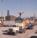
| Description: | View of a man in a red jacket holding paint brushes and a palette while standing atop a truck trailer. The side of the trailer is painted with a mural of f... |
| Date: | 1975 |
|---|---|
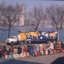
| Description: | View of a group of children in jackets and an adult looking at a mural of endangered big cat species painted on a trailer. The painting was part of one of ... |

| Date: | 1975 |
|---|---|
| Description: | Color photograph of a group of children standing on a sidewalk to wait for an approaching school bus marked "Parish Schools." The bus is built on an Intern... |
| Date: | 1975 |
|---|---|
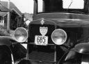
| Description: | A "Keep US Out of War" and a 38 license plate were on a 1930 Chevrolet pickup truck restored by Eldor Streblow. |

| Date: | 1975 |
|---|---|
| Description: | This map shows plat of the city, city limits, local streets, and part of Baraboo River. The map includes 2 inset maps and a legend showing residential, bus... |

| Date: | 1975 |
|---|---|
| Description: | This standard U.S.G.S. topographic map was annotated by civil engineer and railroad historian James P. Kaysen to show the location of existing and defunct ... |

| Date: | 1975 |
|---|---|
| Description: | This map shows streets, railroads, and Wolf Lake. An index of streets is also included. |
| Date: | 1975 |
|---|---|
| Description: | This bird’s-eye-view map is a series of photographs compiled to show local streets and buildings. |

| Date: | 1975 |
|---|---|
| Description: | This map provides an index of outdated quadrangle maps for the state. Communities, counties, rivers, and lakes are labeled including Lake Michigan and Lake... |

| Date: | 1975 |
|---|---|
| Description: | This map shows nature trails, public attractions, public hunting and fishing grounds, dams, waysides, lakes, highways, and roads. The upper right corner in... |
| Date: | 1975 |
|---|---|
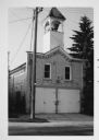
| Description: | View across street towards the Waubeka firehouse at 401 Center Street. In a tower above the entrance is the Red Arrow siren, which has since been removed. |

| Date: | 1975 |
|---|---|
| Description: | This colored road map of Wisconsin displays "Featured Points of Interest" and "Historical Points of Interest" in the state, including three color photograp... |
If you didn't find the material you searched for, our Library Reference Staff can help.
Call our reference desk at 608-264-6535 or email us at:
