Filter: Categories of Wisconsin Historical Images
Filter: FULL_DATE of 1974
Filter: Subject of transportation
Filter: Categories of Wisconsin Historical Images
Filter: FULL_DATE of 1974
Filter: Subject of transportation
| Date: | 1974 |
|---|---|
| Description: | "The Lomira Legion building is framed in the arch of the Highway 67 overhead." |

| Date: | 1974 |
|---|---|
| Description: | "Gordon Neitzel keeps tabs on a village election." |
| Date: | 1974 |
|---|---|
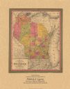
| Description: | A map that was originally published around 1851 in S. Augustus Mitchell's New universal atlas, shows portions of present-day Iron and Vilas counties north ... |
| Date: | 1974 |
|---|---|
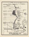
| Description: | This map is a 9 part map detailing various parts of Menominee County, Wisconsin. Page 1 of the map shows federal aid control in the county and was used by ... |

| Date: | 1974 |
|---|---|
| Description: | This 1968 map identifies resorts in the Lac du Flambeau Indian Reservation region of Wisconsin, covering parts of Iron, Vilas, Oneida, and Price counties. ... |

| Date: | 1974 |
|---|---|
| Description: | This 1974 map is a reproduction of the original survey maps of the Four Lakes region of Dane County, Wisconsin. It shows sections, lakes, rivers, wetlands,... |

| Date: | 1974 |
|---|---|
| Description: | A nurse IS examinING an elderly woman in a mobile health unit operated by the Alfred University School of Nursing. The mobile health unit traveled around c... |

| Date: | 1974 |
|---|---|
| Description: | Dr. Virginia Barker, Nursing School Dean at Alfred University, is reading the results of an electrocardiograph in a mobile health unit. The mobile health ... |

| Date: | 1974 |
|---|---|
| Description: | Children are standing on the steps of the Alfred University School of Nursing Mobile Health Unit. The mobile health unit traveled around communities in All... |

| Date: | 1974 |
|---|---|
| Description: | A woman is sitting at a table filling out a ledger. She is wearing red clothing with white piping, and is wearing eyeglasses. She is probably a nurse or nu... |

| Date: | 1974 |
|---|---|
| Description: | A map of Dane County from the Charles Brown Atlas. A hand-drawn blue line marks the Black Hawk Trail. |

| Date: | 1974 |
|---|---|
| Description: | This map shows roads, highways, railroads, major arterials, towns, parks, recreational areas, and parts of Fox River and bay of Green Bay. The map includes... |

| Date: | 1974 |
|---|---|
| Description: | Blue Scout II XLC parked outdoors. Another truck is behind on the right. Forested hill in the background. Snow-capped mountains in the far background. |

| Date: | 1974 |
|---|---|
| Description: | Red/orange Scout II XLC parked in front of a large construction vehicle. A man stands holding open the hatchback. Mountain in the background. |

| Date: | 1974 |
|---|---|
| Description: | Three-quarter view from rear of blue Scout II XLC parked on steep hill in a grassy field. In the background on the left a man sits in another Scout, red/or... |

| Date: | 1974 |
|---|---|
| Description: | Close-up of insignia. Reads: "Scout II XLC." |

| Date: | 1974 |
|---|---|
| Description: | Two men sit in a blue Scout II XLC in a field in a mountainous area. A yellow truck is parked behind them on the right. |
If you didn't find the material you searched for, our Library Reference Staff can help.
Call our reference desk at 608-264-6535 or email us at: