Filter: Categories of Wisconsin Historical Images
Filter: FULL_DATE of 1968
Filter: Subject of transportation
Filter: Categories of Wisconsin Historical Images
Filter: FULL_DATE of 1968
Filter: Subject of transportation
| Date: | 1968 |
|---|---|
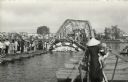
| Description: | Pedestrians file single file across the make-shift repairs to the bridge over the Perfume River at Hue. The bridge was bombed by the Vietcong during the Te... |
| Date: | 1968 |
|---|---|
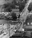
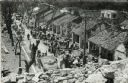
| Description: | Elevated view of refugees after the Tet Offensive, camped out front of their damaged homes. Although not identified, it is believed the image is a street s... |

| Date: | 1968 |
|---|---|
| Description: | Pedestrians and an ARVN soldier on a bicycle crossing a bridge in the city of Hue after the Tet Offensive. |

| Date: | 1968 |
|---|---|
| Description: | The map shows fire towers, public camp grounds, roads, snow mobile & riding trails, trout lakes, foot trails, railroads, and National Forest boundaries. |
| Date: | 1968 |
|---|---|
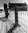
| Description: | "Brenda & Kay Widmer examine an ice covered fence on the Jim Dobbe Farm (Sunny Brae Farm)." |
| Date: | 1968 |
|---|---|
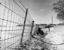
| Description: | "Brenda & Kay Widmer examine an ice covered fence on the Jim Dobbe Farm (Sunny Brae Farm)." |

| Date: | 1968 |
|---|---|
| Description: | "Paul Koll loads empty milk cans at Widmer Cheese Factory." |
| Date: | 1968 |
|---|---|
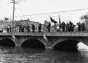
| Description: | "American Legion Post 270 members assemble on the bridge on Memorial Day." |

| Date: | 1968 |
|---|---|
| Description: | Ernesto Chacon, a grape boycott organizer from Milwaukee, is wearing a jacket, sunglasses and a necklace around his neck. He is holding a United Farmworker... |

| Date: | 1968 |
|---|---|
| Description: | On the left, Ernesto Chacon, is in sunglasses and holding a sign that says, "Don't Buy Grapes," picketing for the United Farmworkers/AFL-CIO grape boycott.... |
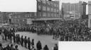
| Date: | 1968 |
|---|---|
| Description: | Composite photograph of an elevated view of an anti-Vietnam War protest at the intersection of Lake and State Streets looking east up State Street. A large... |

| Date: | 1968 |
|---|---|
| Description: | A topographic map of east central Wisconsin, that covers an area stretching from Green Bay on the east to Edgar and Vesper on the west, Wausau on the north... |

| Date: | 1968 |
|---|---|
| Description: | A tourist map of Milwaukee County and of downtown Milwaukee. The Map of Milwaukee County identifies the location of some of the points of interests in the ... |

| Date: | 1968 |
|---|---|
| Description: | This map is ink and color on printed grid. Shows geology, portage trails, timber type, some landownership, hydrology, and marshes in part of Florence Count... |

| Date: | 1968 |
|---|---|
| Description: | Slightly elevated view of men loading milk pails onto the bed of an International pickup truck, while a woman carrying buckets is walking by, accompanied b... |
If you didn't find the material you searched for, our Library Reference Staff can help.
Call our reference desk at 608-264-6535 or email us at: