Filter: Categories of Wisconsin Historical Images
Filter: FULL_DATE of 1968
Filter: Subject of human settlements
Filter: Categories of Wisconsin Historical Images
Filter: FULL_DATE of 1968
Filter: Subject of human settlements

| Date: | 1968 |
|---|---|
| Description: | Pedestrians and an ARVN soldier on a bicycle crossing a bridge in the city of Hue after the Tet Offensive. |

| Date: | 1968 |
|---|---|
| Description: | The map shows fire towers, public camp grounds, roads, snow mobile & riding trails, trout lakes, foot trails, railroads, and National Forest boundaries. |

| Date: | 1968 |
|---|---|
| Description: | "Work in progress as a gym and other rooms are added to the Theresa Public School." |
| Date: | 1968 |
|---|---|
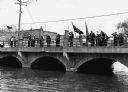
| Description: | "American Legion Post 270 members assemble on the bridge on Memorial Day." |

| Date: | 1968 |
|---|---|
| Description: | Ernesto Chacon, a grape boycott organizer from Milwaukee, is wearing a jacket, sunglasses and a necklace around his neck. He is holding a United Farmworker... |

| Date: | 1968 |
|---|---|
| Description: | On the left, Ernesto Chacon, is in sunglasses and holding a sign that says, "Don't Buy Grapes," picketing for the United Farmworkers/AFL-CIO grape boycott.... |
| Date: | 1968 |
|---|---|
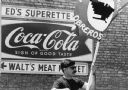
| Description: | Francisco Rodriguez of Crystal City, Texas is picketing a Wautoma grocery store during the grape boycott in 1968. Grape boycotts in Wisconsin were organize... |

| Date: | 1968 |
|---|---|
| Description: | Two men are riding on a cucumber harvesting machine called the "Pickle Harvester" as labeled on the center between two lights. The man on the right, wearin... |
| Date: | 1968 |
|---|---|
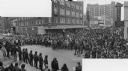
| Description: | Composite photograph of an elevated view of an anti-Vietnam War protest at the intersection of Lake and State Streets looking east up State Street. A large... |

| Date: | 1968 |
|---|---|
| Description: | A topographic map of east central Wisconsin, that covers an area stretching from Green Bay on the east to Edgar and Vesper on the west, Wausau on the north... |

| Date: | 1968 |
|---|---|
| Description: | A tourist map of Milwaukee County and of downtown Milwaukee. The Map of Milwaukee County identifies the location of some of the points of interests in the ... |
| Date: | 1968 |
|---|---|
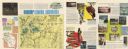
| Description: | This 1960s tourism brochure for Sawyer County, Wisconsin, includes descriptive text, color illustrations, a road map, a distance map, a location map, and l... |

| Date: | 1968 |
|---|---|
| Description: | Shows potential fishing areas by species and season, as well as sand and rock bars, weed beds, public facilities, points of interest, and selected business... |
| Date: | 1968 |
|---|---|
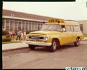
| Description: | Young children are walking down a sidewalk to board an International C-1200 school bus parked outside Springfield North School. A man is sitting in the dri... |
| Date: | 1968 |
|---|---|
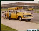
| Description: | View towards a group of students boarding an International C-1100 school bus outside Springfield North School. A manis sitting in the driver's seat. |
| Date: | 1968 |
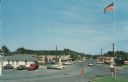
|---|---|
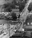
| Description: | Elevated view of the main business district. Cars are parked in front of businesses, and are driving down the road. A flagpole and stop signs are in the fo... |
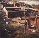
| Date: | 1968 |
|---|---|
| Description: | Elevated view looking down over the railroad station district. |

| Date: | 1968 |
|---|---|
| Description: | This map shows local streets, wards, buildings, parks, and part of the Fox River. The map is also indexed by street name. Ward borders and numbering and th... |
If you didn't find the material you searched for, our Library Reference Staff can help.
Call our reference desk at 608-264-6535 or email us at: