 Filter: Categories of Wisconsin Historical Images
Filter: FULL_DATE of 1965
Filter: Subject of education
Filter: Categories of Wisconsin Historical Images
Filter: FULL_DATE of 1965
Filter: Subject of education
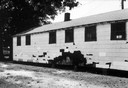
| Date: | 1965 |
|---|---|
| Description: | Back view of a black high school showing damage on a wall. SNCC Arkansas Project. |
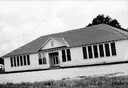
| Date: | 1965 |
|---|---|
| Description: | Front view of a high school for African American students. SNCC Arkansas Project. |
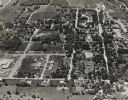
| Date: | 1965 |
|---|---|
| Description: | Aerial view of Iola, Wisconsin looking west. Located in the lower left corner is an elementary school. |

| Date: | 1965 |
|---|---|
| Description: | Jim Dombrowski, Secretary of Highlander Folk School, lecturing using an Amalgamated Clothing Workers Visual-Lecture Sheet. |

| Date: | 1965 |
|---|---|
| Description: | Child's Valentine's Day card with a boy and a girl. He is wearing shorts, jacket, eyeglasses, and a graduation cap. He holds a slate in one hand with the t... |

| Date: | 1965 |
|---|---|
| Description: | Assemblyman David R. Obey and Patrick J. Lucey meeting with a group of students and their teacher, a nun, in the Wisconsin Assembly Parlor. Although undat... |

| Date: | 1965 |
|---|---|
| Description: | Students in a Freedom School singing and clapping in an image taken by a civil rights volunteer. "Freedom School - Freedom singing led by youngsters and... |

| Date: | 1965 |
|---|---|
| Description: | Image of a Freedom School classroom taken by a civil rights volunteer. Students are seated in what appear to be pews. "Freedom School - Freddie Green,... |
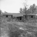
| Date: | 1965 |
|---|---|
| Description: | The school used for African-American children in the western half of Clay County until 1960, pictured 5 years after it closed. |

| Date: | 1965 |
|---|---|
| Description: | A man sits in the driver's seat and children sit in the back of an International Metro school bus. The bus is on a gravel road and in the background is a f... |

| Date: | 1965 |
|---|---|
| Description: | A white volunteer teaches a young African-American boy at a desk in front of a bookcase. Used in a brochure with the title, 'SNCC Summer 1965.' |
| Date: | 1965 |
|---|---|
| Description: | This map shows Milwaukee County Parkway lands, streets, streets not yet constructed, public facilities, schools, churches, and manufacturers. The map inclu... |

| Date: | 1965 |
|---|---|
| Description: | This basic street map shows roads, schools, parks and cemeteries and includes a street index in the lower margin. The map also shows a portion of Elm Grove... |
| Date: | 1965 |
|---|---|
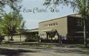
| Description: | Photographic postcard view from street towards the Wisconsin State College in Eau Claire. Students are on the sidewalk. Caption reads: "Eau Claire, Wis." |

| Date: | 1965 |
|---|---|
| Description: | This map shows proposed streets, arterial and collector streets, lot numbers and dimensions, parks, the disposal plant, a ball park, and school property. T... |

| Date: | 1965 |
|---|---|
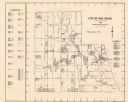
| Description: | This map shows wards, city limits, railroad right of way, proposed future streets, and approximate street elevations. Wards and public schools are labeled ... |

| Date: | 1965 |
|---|---|
| Description: | This map shows streets, churches, schools, wards, railroads, parks and fields, cemeteries, Historical Museum, Yacht Basin & Marina, and Marinette General H... |

| Date: | 1965 |
|---|---|
| Description: | This map shows wards, schools and public buildings, and polling places. The map includes a street index. Lac La Belle, Fowler Lake, and Oconomowoc Lake are... |
| Date: | 1965 |
|---|---|
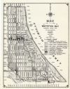
| Description: | This map shows 8 zoning districts, as well as house number system, schools, parks, churches, and points of interest. Lake Michigan is labeled and the lower... |

| Date: | 1965 |
|---|---|
| Description: | Air view of the west end of University of Wisconsin-Madison campus with U.W. Hospital and U.W. athletic fields at top. Campus Drive and University Avenue r... |
If you didn't find the material you searched for, our Library Reference Staff can help.
Call our reference desk at 608-264-6535 or email us at: