Filter: Categories of Wisconsin Historical Images
Filter: FULL_DATE of 1965
Filter: Creator Name of Unknown
Filter: Subject of transportation
Filter: Subject of human settlements
Filter: Categories of Wisconsin Historical Images
Filter: FULL_DATE of 1965
Filter: Creator Name of Unknown
Filter: Subject of transportation
Filter: Subject of human settlements
| Date: | 1965 |
|---|---|
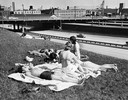
| Description: | Women sun bathe near an express highway in Milwaukee. |

| Date: | 1965 |
|---|---|
| Description: | Aerial view of downtown Big Falls and the Little Wolf River. The Little Wolf River is at lower right. |

| Date: | 1965 |
|---|---|
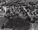
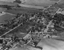
| Description: | Aerial view of town and Highway 66. |

| Date: | 1965 |
|---|---|
| Description: | The Robert M. Bashford house at 423 North Pinckney Street. |

| Date: | 1965 |
|---|---|
| Description: | The James Bowen House at 302 South Mills Street. There is a station wagon parked in front of the building. |
| Date: | 1965 |
|---|---|
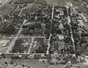
| Description: | Aerial view of Iola, Wisconsin looking west. Located in the lower left corner is an elementary school. |

| Date: | 1965 |
|---|---|
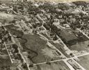
| Description: | Aerial view that encompasses most of the town and part of the Wisconsin River. |
| Date: | 1965 |
|---|---|
| Description: | Aerial view, looking west, with potato warehouses in the foreground and a pallet factory and junkyard behind them at right. |

| Date: | 1965 |
|---|---|
| Description: | Aerial view of early construction at the Marquette Interchange in Milwaukee, the junction of Interstate Highways I94 and I43. Construction began in 1964, ... |

| Date: | 1965 |
|---|---|
| Description: | Aerial view looking north-northwest. View includes houses, roads, farm buildings, tractor-trailors (parked), other buildings. |
| Date: | 1965 |
|---|---|
| Description: | Aerial view, looking east. Highway 49 is at center. |
| Date: | 1965 |
|---|---|
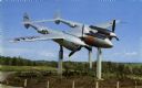
| Description: | View of the Bong Memorial, dedicated to the memory of World War II air ace Major Richard I. Bong. This P-38 is the type of plane he piloted when he shot do... |

| Date: | 1965 |
|---|---|
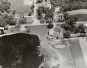
| Description: | Elevated view of roads, railroad tracks, building, farm fields, and a body of water. |

| Date: | 1965 |
|---|---|
| Description: | View down sidewalk of the Clay County welfare office. The caption on the back of the image reports that African-Americans who received welfare were treated... |

| Date: | 1965 |
|---|---|
| Description: | This map shows proposed streets, arterial and collector streets, lot numbers and dimensions, parks, the disposal plant, a ball park, and school property. T... |
| Date: | 1965 |
|---|---|
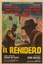
| Description: | Argentine film poster. Illustrated image of two men fighting in the street with knives. They are both wearing hats and suits. |

| Date: | 1965 |
|---|---|
| Description: | This map shows wards, city limits, railroad right of way, proposed future streets, and approximate street elevations. Wards and public schools are labeled ... |

| Date: | 1965 |
|---|---|
| Description: | This map is indexed for public buildings and includes a numbered key on the lower left side. The streets are labeled and Lake Michigan is labeled on the fa... |
If you didn't find the material you searched for, our Library Reference Staff can help.
Call our reference desk at 608-264-6535 or email us at: