Filter: Categories of Wisconsin Historical Images
Filter: FULL_DATE of 1965
Filter: Creator Name of Unknown
Filter: Subject of streets
Filter: Categories of Wisconsin Historical Images
Filter: FULL_DATE of 1965
Filter: Creator Name of Unknown
Filter: Subject of streets

| Date: | 1965 |
|---|---|
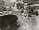
| Description: | Aerial view of downtown Big Falls and the Little Wolf River. The Little Wolf River is at lower right. |

| Date: | 1965 |
|---|---|
| Description: | The Robert M. Bashford house at 423 North Pinckney Street. |
| Date: | 1965 |
|---|---|
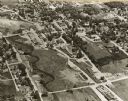
| Description: | Aerial view of Iola, Wisconsin looking west. Located in the lower left corner is an elementary school. |
| Date: | 1965 |
|---|---|
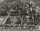
| Description: | Aerial view, looking east. Highway 49 is at center. |

| Date: | 1965 |
|---|---|
| Description: | View down sidewalk of the Clay County welfare office. The caption on the back of the image reports that African-Americans who received welfare were treated... |

| Date: | 1965 |
|---|---|
| Description: | This map shows proposed streets, arterial and collector streets, lot numbers and dimensions, parks, the disposal plant, a ball park, and school property. T... |

| Date: | 1965 |
|---|---|
| Description: | Argentine film poster. Illustrated image of two men fighting in the street with knives. They are both wearing hats and suits. |

| Date: | 1965 |
|---|---|
| Description: | This map shows wards, city limits, railroad right of way, proposed future streets, and approximate street elevations. Wards and public schools are labeled ... |

| Date: | 1965 |
|---|---|
| Description: | This map is indexed for public buildings and includes a numbered key on the lower left side. The streets are labeled and Lake Michigan is labeled on the fa... |

| Date: | 1965 |
|---|---|
| Description: | View down center of tree-lined State Street towards Lake Street, with automobile traffic moving up and down the street. On the left behind a row of trees i... |

| Date: | 1965 |
|---|---|
| Description: | View down center of State Street, with automobile traffic moving up and down the street, towards the Wisconsin State Capitol. On the corner of W. Johnson S... |

| Date: | 1965 |
|---|---|
| Description: | View down center of State Street towards the intersection of W. Gorham Street. On the near left corner is the Badger Liquor Shop. On the right on the other... |

| Date: | 1965 |
|---|---|
| Description: | View down center of State Street at the intersection of W. Gilman Street. On the left men are working near construction barriers in the street in front of ... |

| Date: | 1965 |
|---|---|
| Description: | View down center of State Street towards Lake Street. On the left is the University Book Store, and on further down across Lake Street is Rennebohm's and W... |
If you didn't find the material you searched for, our Library Reference Staff can help.
Call our reference desk at 608-264-6535 or email us at: