Filter: Categories of Wisconsin Historical Images
Filter: FULL_DATE of 1964
Filter: Subject of water
Filter: Categories of Wisconsin Historical Images
Filter: FULL_DATE of 1964
Filter: Subject of water

| Date: | 1964 |
|---|---|
| Description: | Aerial view of the Milwaukee County Zoo grounds nearing its completion. |

| Date: | 1964 |
|---|---|
| Description: | Foreign correspondent, Russell Jones, on assignement. Jones worked for ABC News, and is being filmed for an evening news segment on political events in Bud... |

| Date: | 1964 |
|---|---|
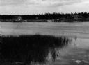
| Description: | The Queen of the Lake boat launch on State Highway 23 in Green Lake County. |
| Date: | 1964 |
|---|---|
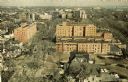
| Description: | Elevated view of the city looking north along the shore of Lake Michigan. |

| Date: | 1964 |
|---|---|
| Description: | Marshfield Airways, covered with snow. A river full of ice and snow, with boats along the shoreline, is in the lower portion of the image. |

| Date: | 1964 |
|---|---|
| Description: | An aerial view of the U.S. Rubber Company plant and surrounding environment. |

| Date: | 1964 |
|---|---|
| Description: | An aerial view of the U.S. Rubber Company plant and surrounding environment. |

| Date: | 1964 |
|---|---|
| Description: | "Mayville photographer, Edgar G. Mueller, covers a parade in Theresa." |

| Date: | 1964 |
|---|---|
| Description: | This 1964 maps shows roads, boat landings and marinas, campgrounds, canoe trails and portages, and lakes and streams in parts of Vilas, Oneida, and Iron co... |

| Date: | 1964 |
|---|---|
| Description: | This 1964 map of Madeline Island, Ashland County, Wisconsin, shows existing and historical locations, roads, the boundaries of a proposed state park, secti... |

| Date: | 1964 |
|---|---|
| Description: | Shows local streets, bus routes, highways, airport, Dells Pond, Half Moon Lake, Chippewa River, and Eau Claire River. Includes 2 inset maps: Location map a... |

| Date: | 1964 |
|---|---|
| Description: | Indexed map. Street names are to the left, map is to the right. Lakes, streets, highways, and points of interest are labelled. |

| Date: | 1964 |
|---|---|
| Description: | A simple map of the Mississippi Project. There are symbols at the bottom marking locations for: Voter Registration, Freedom School, Community Center and Pr... |

| Date: | 1964 |
|---|---|
| Description: | This map of Two Rivers shows the Rodgers street fishing area and land use. The map features a legend on the right of the types of land use. The map also sh... |
| Date: | 1964 |
|---|---|
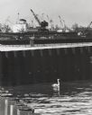
| Description: | Docks at Jones Island with a lone swan swimming. Many large ships and city buildings can be seen in the background. |

| Date: | 1964 |
|---|---|
| Description: | This map is a hand-colored blue line print and shows 4 residence zones, 2 business zones, 1 light manufacturing zones, schools, and parks. The zones are ou... |

| Date: | 1964 |
|---|---|
| Description: | Men and young children in a roofed enclosure outside a dwelling near the village of Binh Hung, South Vietnam. Several of the children are plugging their ea... |
| Date: | 1964 |
|---|---|
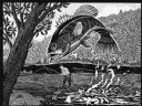
| Description: | Imaginative pen-and-ink drawing of a view from a riverbank of a fly fisherman in hip waders, who is standing in a stream while hooking a bass. The fish is ... |
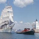
| Date: | 1964 |
|---|---|
| Description: | View across water towards the tugboat "Indiana" pulling the full-rigged, three-masted Norwegian ship "Christian Radich" into port. The sails and hull of th... |
If you didn't find the material you searched for, our Library Reference Staff can help.
Call our reference desk at 608-264-6535 or email us at: