 Filter: Categories of Wisconsin Historical Images
Filter: FULL_DATE of 1960
Filter: Subject of transportation
Filter: Categories of Wisconsin Historical Images
Filter: FULL_DATE of 1960
Filter: Subject of transportation

| Date: | 1960 |
|---|---|
| Description: | This manuscript map of Taylor County, Wisconsin, shows the township and range grid, lakes and streams, "Chippewa trails, Indian trails" Indian villages and... |

| Date: | 1960 |
|---|---|
| Description: | Color coded map in pink, yellow, blue, and brown of Milwaukee County State and County trunk highways. The map includes a legend of symbols: "STEAM RAIL ROA... |

| Date: | 1960 |
|---|---|
| Description: | Color photo of the Universal Engineer Armored Tractor. This vehicle provides the United States Army, Corps of Engineers, with protected mobility and suppor... |

| Date: | 1960 |
|---|---|
| Description: | Three-quarter view from front of the light version of a Universal Engineer Tractor. The original caption reads: "Here is how the unarmored UET appeared." |

| Date: | 1960 |
|---|---|
| Description: | Color photo of the Universal Engineer Tractor. The original caption reads: "Ready for combat — by land or water, and air transportable, the UET-E1 (Armored... |

| Date: | 1960 |
|---|---|
| Description: | The original caption reads: "Primary mission for the army's present personnel carrier is just one possible assignment for the UET-E1. The 10-man Combat Eng... |

| Date: | 1960 |
|---|---|
| Description: | The original caption reads: "Palleted cargoes can be loaded and unloaded by attaching the pallet to the eye located in the center lower area of the ejector... |

| Date: | 1960 |
|---|---|
| Description: | This map of Greedale shows local streets, parks, schools, and churches and includes manuscript annotations in green and blue showing tracts and parcels of ... |

| Date: | 1960 |
|---|---|
| Description: | Evening view of the Westgate Shopping Center reflected in Montgomery Ward store window at the time of opening, while the center was still partially under c... |

| Date: | 1960 |
|---|---|
| Description: | View looking down on Pinckney Street, with a section of Capitol park, from the Belmont Hotel. |

| Date: | 1960 |
|---|---|
| Description: | This map shows a plat of the city, wards, lots, local streets, roads, railroads, buildings, parks, and part of Fox River. The map includes tables for plat ... |

| Date: | 1960 |
|---|---|
| Description: | This map shows lot and block numbers, additions, and rural acreages and includes an index of rail roads, industrial plants, Dunn County and Menominee owned... |
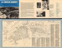
| Date: | 1960 |
|---|---|
| Description: | This map is oriented with north to the right and includes an index of streets. The back of the map features text about La Crosse. |

| Date: | 1960 |
|---|---|
| Description: | This map is a cadastral map and shows block and lot numbers and dimensions, additions, streets, railroad, and Kiel Municipal Cemetery. The bottom right mar... |

| Date: | 1960 |
|---|---|
| Description: | This map shows local streets, wards, public buildings, parks, and part of the Fox River. The land is shown in white and the water is shown in blue. The map... |

| Date: | 1960 |
|---|---|
| Description: | This map shows lot numbers and dimensions, railroad, and streets. Fall Creek and Mill Pond (now Fall Creek Pond) are labeled. The map is a blue line print. |

| Date: | 1960 |
|---|---|
| Description: | Several men are working with logs and equipment in Brule River State Forest. |

| Date: | 1960 |
|---|---|
| Description: | Several piles of logs along a logging road waiting for truck pick up. |

| Date: | 1960 |
|---|---|
| Description: | Chrome color postcard of the boat launch area. Text on back reads: "Forest County Veteran's Memorial Park located 3 miles from Crandon, WI on the south sho... |

| Date: | 1960 |
|---|---|
| Description: | Elevated view of fifty Scout snow plows parked outdoors in a large field. There are factory buildings in the background. |
If you didn't find the material you searched for, our Library Reference Staff can help.
Call our reference desk at 608-264-6535 or email us at: