Filter: Categories of Wisconsin Historical Images
Filter: FULL_DATE of 1960
Filter: Subject of boats and boating
Filter: Categories of Wisconsin Historical Images
Filter: FULL_DATE of 1960
Filter: Subject of boats and boating
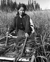
| Date: | 1960 |
|---|---|
| Description: | An Ojibwa woman, Francis Mike, harvesting wild rice in a boat on Totogatic Lake. |
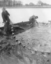
| Date: | 1960 |
|---|---|
| Description: | Slightly elevated view across water towards men fishing from a boat below the dam on the Fox River. Two other men are standing on the right shoreline near ... |

| Date: | 1960 |
|---|---|
| Description: | Views of popular sites in Madison. Numerous different types of recreation are depicted, along with popular sites such as the Wisconsin State Capitol buildi... |
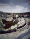
| Date: | 1960 |
|---|---|
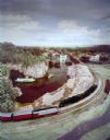
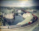
| Description: | S-1 freight meets circus train at the Dells Minirama. DBC, Steamboat Winnebago, powerhouse. |
| Date: | 1960 |
|---|---|
| Description: | Steamboat Hiawatha meeting circus train at the Dells minirama (miniature model), bridge, DBC steamboat and launch. |
| Date: | 1960 |
|---|---|
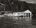
| Description: | Wet boathouse that belonged to Don Walkins, on Catfish Lake. A woman stands on a pier near a boat. |
| Date: | 1960 |
|---|---|
| Description: | Wisconsin Dells Minirama (miniature model) featuring a circus train on a bridge. |

| Date: | 1960 |
|---|---|
| Description: | Chrome color postcard of the boat launch area. Text on back reads: "Forest County Veteran's Memorial Park located 3 miles from Crandon, WI on the south sho... |

| Date: | 1960 |
|---|---|
| Description: | This map shows public boat ramps, parks, highways, beaches, bluffs, Green Bay, Garrett Bay, Europe Bay and Lake, Rowley's Bay and Ellison Bay. The map incl... |

| Date: | 1960 |
|---|---|
| Description: | This pictorial map shows recreation activities, rivers, lakes, and the history of the area. The map covers Langlade County and parts of adjacent counties. ... |

| Date: | 1960 |
|---|---|
| Description: | This map shows improved town roads, federal highways, county highways, public boat access, public hunting areas, railroads, and lakes in the area around th... |

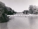
| Date: | 1960 |
|---|---|
| Description: | View from shoreline towards a marina in Green Lake. |

| Date: | 1960 |
|---|---|
| Description: | Color elevated view of Inspiration Point on Green Lake. The swimming pool is in the foreground. At a dock are several moored rowboats and an excursion boat... |
If you didn't find the material you searched for, our Library Reference Staff can help.
Call our reference desk at 608-264-6535 or email us at: