Filter: Categories of Wisconsin Historical Images
Filter: FULL_DATE of 1960
Filter: Reproduction Rights of For Sale
Filter: Categories of Wisconsin Historical Images
Filter: FULL_DATE of 1960
Filter: Reproduction Rights of For Sale

| Date: | 1960 |
|---|---|
| Description: | Color coded map in pink, yellow, blue, and brown of Milwaukee County State and County trunk highways. The map includes a legend of symbols: "STEAM RAIL ROA... |

| Date: | 1960 |
|---|---|
| Description: | Color photo of the Universal Engineer Armored Tractor. This vehicle provides the United States Army, Corps of Engineers, with protected mobility and suppor... |

| Date: | 1960 |
|---|---|
| Description: | Three-quarter view from front of the light version of a Universal Engineer Tractor. The original caption reads: "Here is how the unarmored UET appeared." |

| Date: | 1960 |
|---|---|
| Description: | Color photo of the Universal Engineer Tractor. The original caption reads: "Ready for combat — by land or water, and air transportable, the UET-E1 (Armored... |
| Date: | 1960 |
|---|---|
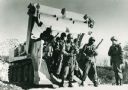
| Description: | The original caption reads: "Primary mission for the army's present personnel carrier is just one possible assignment for the UET-E1. The 10-man Combat Eng... |

| Date: | 1960 |
|---|---|
| Description: | The original caption reads: "The Universal Engineer Tractor never turns down a job. Bulldozing ability was designed in and built into this vehicle. Self-lo... |

| Date: | 1960 |
|---|---|
| Description: | The original caption reads: "Palleted cargoes can be loaded and unloaded by attaching the pallet to the eye located in the center lower area of the ejector... |

| Date: | 1960 |
|---|---|
| Description: | A hand-drawn map showing the "Negro Percentage of Each County's Population" in Mississippi. |

| Date: | 1960 |
|---|---|
| Description: | Colorized postcard view of bartenders and group of people at an Egyptian-themed cocktail bar, the Pyramid Supper Club, in Beaver Dam, Wisconsin. |

| Date: | 1960 |
|---|---|
| Description: | View down slope across open fields over a barbed wire fence towards the horizon. The field is uncut in the foreground, obscuring an abandoned farm implemen... |
| Date: | 1960 |
|---|---|
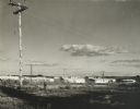
| Description: | New residential construction on the outer southwest edge of Madison. |

| Date: | 1960 |
|---|---|
| Description: | Hardwood growth in the Madison School Forest. |

| Date: | 1960 |
|---|---|
| Description: | Flowering bush on Rocky Dell Road. |
| Date: | 1960 |
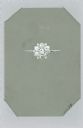
|---|---|
| Description: | Hand-colored drawing on translucent plastic mounted in a card, of a design for a ring with thirteen stones. It is labeled "No. 2" and the number 11079 appe... |

| Date: | 1960 |
|---|---|
| Description: | This map of Greedale shows local streets, parks, schools, and churches and includes manuscript annotations in green and blue showing tracts and parcels of ... |

| Date: | 1960 |
|---|---|
| Description: | Elevated view of landscape, with large dead birch tree, looking south east near the junction of Highways 19 and 78. |
If you didn't find the material you searched for, our Library Reference Staff can help.
Call our reference desk at 608-264-6535 or email us at: