 Filter: Categories of Wisconsin Historical Images
Filter: FULL_DATE of 1959
Filter: Subject of transportation
Filter: Subject of land
Filter: Categories of Wisconsin Historical Images
Filter: FULL_DATE of 1959
Filter: Subject of transportation
Filter: Subject of land

| Date: | 1959 |
|---|---|
| Description: | Elevated view looking east from shoreline of Lake Monona towards Monona shoreline. There is a road, railroad tracks, and a rocky beach area with parked au... |
| Date: | 1959 |
|---|---|
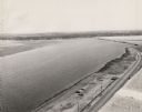
| Description: | Elevated view looking south over Lake Monona. Shoreline and automobiles in parking lot in lower right, next to a road. Railroad tracks cross the lake and b... |

| Date: | 1959 |
|---|---|
| Description: | Aerial view of the island of Cuba taken from a small plane. Part of the plane with a Cuban flag painted on it is in the frame, and the island with many bui... |
| Date: | 1959 |
|---|---|
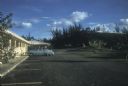
| Description: | Motel that was formerly a clandestine safe-house for the 26th of July Movement during the Cuban Revolution. Parking lot with a blue car in front of a pink,... |

| Date: | 1959 |
|---|---|
| Description: | Color photo of an International truck driving beneath a bridge spanning a dam on the Colorado River. |
| Date: | 1959 |
|---|---|
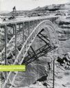
| Description: | An International truck sits on a bridge spanning Glen Canyon and the Colorado River. |

| Date: | 1959 |
|---|---|
| Description: | International trucks parked near a bridge construction site. |

| Date: | 1959 |
|---|---|
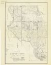
| Description: | This map identifies public forest land and industrial forest land as of 1959 in Oneida County, Wisconsin, using a 1930 base map showing the township and ra... |
| Date: | 1959 |
|---|---|
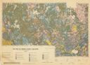
| Description: | Map of soil in Oneida County. Bottom of the map includes a legend of soil; "SECOND CLASS SOILS GOOD TO FAIR FARM LAND" are represented in shades of yellow ... |

| Date: | 1959 |
|---|---|
| Description: | Aerial view of the Westgate Shopping Center under construction. |

| Date: | 1959 |
|---|---|
| Description: | This map of Lake Geneva has relief shown by contours and water depths shown by isolines. The map includes an index of schools, churches, public services, i... |
| Date: | 1959 |
|---|---|
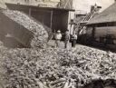
| Description: | An official and workmen at Hillsboro Canning Plant examining a a large truckload of corn as it's dumped into a huge unloading platform. The individuals pic... |

| Date: | 1959 |
|---|---|
| Description: | Original Scout drawing circa 1959. |

| Date: | 1959 |
|---|---|
| Description: | This map shows wards and precincts by number, local streets, roads, parks, Shorewood Hills, Maple Bluff, Middleton, Verona, McFarland, Monona, Truax Field,... |

| Date: | 1959 |
|---|---|
| Description: | This map shows landownership, acreages, and old fort road on the southwest corner of Madeline Island. The map includes an explanation of survey in the midd... |
| Date: | 1959 |
|---|---|
| Description: | This map shows roads, landowners, acreages, and buildings. |
If you didn't find the material you searched for, our Library Reference Staff can help.
Call our reference desk at 608-264-6535 or email us at: