Filter: Categories of Wisconsin Historical Images
Filter: FULL_DATE of 1956
Filter: Subject of rivers
Filter: Categories of Wisconsin Historical Images
Filter: FULL_DATE of 1956
Filter: Subject of rivers

| Date: | 1956 |
|---|---|
| Description: | Aerial view looking northeast from a point over the east end of Middleton, showing the west end of Lake Mendota (right mid-ground). Fox Bluff juts into the... |

| Date: | 1956 |
|---|---|
| Description: | Includes street index. Shows local streets, parks, highways, railroads, Fond du Lac River, and part of lake Winnebago. Also includes text on points of inte... |

| Date: | 1956 |
|---|---|
| Description: | Includes street index and index to points of interest. Shows land ownership by name, plat of town, local streets, schools, parks, highways, railroads, ward... |

| Date: | 1956 |
|---|---|
| Description: | This map of Racine includes a street directory and index of public buildings. Streets, points of interest, Lake Michigan, and the Root River are labeled. A... |

| Date: | 1956 |
|---|---|
| Description: | This maps shows voting precincts and polling places as well as wards. Streets and the Sheboygan River are labeled. The bottom right of the map features a l... |

| Date: | 1956 |
|---|---|
| Description: | This map shows Lake Wisconsin, roads, highways, parks, resort areas, camps, gardens, and Wisconsin State experimental game and fur farm. The back of the ma... |

| Date: | 1956 |
|---|---|
| Description: | This map shows reservation boundaries, U.S. township lines, highways, roads, rivers, and lakes. The lower left corner of the map includes a legend of "Conv... |

| Date: | 1956 |
|---|---|
| Description: | This map shows city, suburban, parochial and other types schools, with an explanation of symbols in the right margin. The original caption for the map read... |

| Date: | 1956 |
|---|---|
| Description: | This colored road map shows automobile roads in Wisconsin as well as portions of nearby states. The map is organized such that a single map of Wisconsin is... |
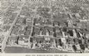
| Date: | 1956 |
|---|---|
| Description: | Caption reads: "Aerial View, Downtown Section, Green Bay, Wis." Text on reverse reads: "This aerial view shows the downtown district of the east side of ... |
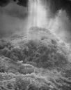
| Date: | 1956 |
|---|---|
| Description: | A sunbeam highlights a torrent of water, below the the falls, on the Amnicon River during the spring thaw. |

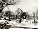
| Date: | 1956 |
|---|---|
| Description: | Snow is mounded on top of pilings on the edge of the Milwaukee River. |

| Date: | 1956 |
|---|---|
| Description: | Water cascades beneath a footbridge and over boulders on a river. A canopy of trees is overhead. |

| Date: | 1956 |
|---|---|
| Description: | Fresh snow on the wooded banks of the Fox River. |
If you didn't find the material you searched for, our Library Reference Staff can help.
Call our reference desk at 608-264-6535 or email us at: