 Filter: Categories of Wisconsin Historical Images
Filter: FULL_DATE of 1956
Filter: Subject of cities and towns
Filter: Categories of Wisconsin Historical Images
Filter: FULL_DATE of 1956
Filter: Subject of cities and towns
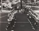
| Date: | 1956 |
|---|---|
| Description: | Uniformed boys' bugle corps passing along a street in a parade. A group of people watch from the sidewalk across the street. |
| Date: | 1956 |
|---|---|
| Description: | This map shows streets and railroads and is oriented with north to the upper left. Wards have been outlined in yellow, red, blue, and green. The back of th... |

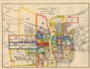
| Date: | 1956 |
|---|---|
| Description: | This maps shows voting precincts and polling places as well as wards. Streets and the Sheboygan River are labeled. The bottom right of the map features a l... |

| Date: | 1956 |
|---|---|
| Description: | Intended for tourists, this brochure features a map of Milwaukee's central business district as well as general information about parking, beaches and othe... |

| Date: | 1956 |
|---|---|
| Description: | This map shows Lake Wisconsin, roads, highways, parks, resort areas, camps, gardens, and Wisconsin State experimental game and fur farm. The back of the ma... |

| Date: | 1956 |
|---|---|
| Description: | This map shows local streets, roads, railroads, highways, parks, cemeteries, hospitals, the University of Wisconsin, Middleton, Maple Bluff, Shorewood Hill... |

| Date: | 1956 |
|---|---|
| Description: | This map shows reservation boundaries, U.S. township lines, highways, roads, rivers, and lakes. The lower left corner of the map includes a legend of "Conv... |
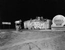
| Date: | 1956 |
|---|---|
| Description: | Night view of a Shell service station with Christmas decorations. There are tree branch swags on the building and on the poles and light fixture around the... |

| Date: | 1956 |
|---|---|
| Description: | This map shows city, suburban, parochial and other types schools, with an explanation of symbols in the right margin. The original caption for the map read... |
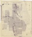
| Date: | 1956 |
|---|---|
| Description: | This blueline print map shows streets, pedestrian pathways, plans to widen existing streets, and streets and alleys vacated and to be vacated. The upper le... |

| Date: | 1956 |
|---|---|
| Description: | This colored road map shows automobile roads in Wisconsin as well as portions of nearby states. The map is organized such that a single map of Wisconsin is... |
| Date: | 1956 |
|---|---|
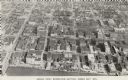
| Description: | Caption reads: "Aerial View, Downtown Section, Green Bay, Wis." Text on reverse reads: "This aerial view shows the downtown district of the east side of ... |

| Date: | 1956 |
|---|---|
| Description: | Color reproduction of a four-story brick hospital with cars parked at the curbs. A fire hydrant is on the corner. |

| Date: | 1956 |
|---|---|
| Description: | Exterior view of the public school, a brick one-story building. Caption reads: "Public School, Hillsboro, Wis." |

| Date: | 1956 |
|---|---|
| Description: | Color postcard of the depot building in Iola. A caboose is on the railroad tracks on the right side. Text on reverse reads: "The Depot, Iola, Wisconsin.... |

| Date: | 1956 |
|---|---|
| Description: | A mailman is trudging through the snow with his loaded mailbag. A city street and buildings are barely visible through the snow. |
| Date: | 1956 |
|---|---|
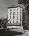
| Description: | View down road towards two people walking in front of the Thienville Mills, a five-story stone building, built in 1876. At this time, it was the Thiensvill... |

| Date: | 1956 |
|---|---|
| Description: | Snow is mounded on top of pilings on the edge of the Milwaukee River. |

| Date: | 1956 |
|---|---|
| Description: | The Amelia-D is docked at a pier on Green Bay. The shoreline and clouds are in the background. A sailboat and motorboat are moored in the distance. |
| Date: | 1956 |
|---|---|
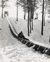
| Description: | An adult and a child riding a toboggan down the slide at Iverson Park. |
If you didn't find the material you searched for, our Library Reference Staff can help.
Call our reference desk at 608-264-6535 or email us at: