 Filter: Categories of Wisconsin Historical Images
Filter: FULL_DATE of 1956
Filter: Type of Map or Atlas
Filter: Categories of Wisconsin Historical Images
Filter: FULL_DATE of 1956
Filter: Type of Map or Atlas
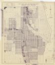
| Date: | 1956 |
|---|---|
| Description: | This blueline print map shows streets, pedestrian pathways, plans to widen existing streets, and streets and alleys vacated and to be vacated. The upper le... |

| Date: | 1956 |
|---|---|
| Description: | This colored road map shows automobile roads in Wisconsin as well as portions of nearby states. The map is organized such that a single map of Wisconsin is... |
If you didn't find the material you searched for, our Library Reference Staff can help.
Call our reference desk at 608-264-6535 or email us at: