 Filter: Categories of Wisconsin Historical Images
Filter: FULL_DATE of 1955
Filter: Year of 1900-1999
Filter: Subject of michigan, lake
Filter: Categories of Wisconsin Historical Images
Filter: FULL_DATE of 1955
Filter: Year of 1900-1999
Filter: Subject of michigan, lake

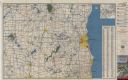
| Date: | 1955 |
|---|---|
| Description: | This map shows roads, trails, county lines, town borders, section lines, railroads, rivers, lakes, and Lake Michigan on the far right. The bottom margin in... |
| Date: | 1955 |
|---|---|
| Description: | This colored road map shows automobile roads in Southeastern Wisconsin on the front and Milwaukee on the back. On the front side of the map, information on... |

| Date: | 1955 |
|---|---|
| Description: | Wind Point Lighthouse surrounded by outbuildings and framed by trees. Lake Michigan is in the distance. |
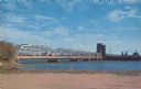
| Date: | 1955 |
|---|---|
| Description: | Text on reverse reads: "Sturgeon Bay Drawbridge Spanning, Sturgeon Bay Canal, Sturgeon Bay, Wis." Traffic is backed up as a ship passes through the span of... |
If you didn't find the material you searched for, our Library Reference Staff can help.
Call our reference desk at 608-264-6535 or email us at: