 Filter: Categories of Wisconsin Historical Images
Filter: FULL_DATE of 1955
Filter: Subject of transportation
Filter: County of Dane
Filter: Categories of Wisconsin Historical Images
Filter: FULL_DATE of 1955
Filter: Subject of transportation
Filter: County of Dane
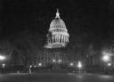
| Date: | 1955 |
|---|---|
| Description: | A nighttime view of the Wisconsin State Capitol as seen from Monona Avenue (South Wisconsin Avenue until December 1, 1877; Martin Luther King Jr. Boulevard... |
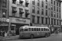
| Date: | 1955 |
|---|---|
| Description: | Bus traveling down Mifflin Street on Capitol Square. Moseleys, Woldenbergs and Walgreen's Drugs are on the right. |

| Date: | 1955 |
|---|---|
| Description: | An air view of Madison's downtown area with the Wisconsin State Capitol and new State Office Buildings. |

| Date: | 1955 |
|---|---|
| Description: | Aerial view of Atwood Avenue, looking west towards Winnebago Street and "Schenk's Corners." |

| Date: | 1955 |
|---|---|
| Description: | Chicago and Northwestern Railroad (CN&W) tracks between Brearly and Ingersoll Streets. |
| Date: | 1955 |
|---|---|
| Description: | West Doty Street, from Monona Avenue looking toward South Carroll Street, showing the back side of Madison Newspapers, Inc. The building was added on to in... |
| Date: | 1955 |
|---|---|
| Description: | The intersection of Johnson and Broom Streets. |

| Date: | 1955 |
|---|---|
| Description: | View down Monona Avenue, which is now Martin Luther King, Jr. Boulevard, toward Lake Monona. |
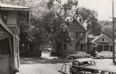
| Date: | 1955 |
|---|---|
| Description: | View of two houses (108 N. Blount and 102 N. Blount) on North Blount Street taken from Market Place showing a corner of the City Market on the left. |
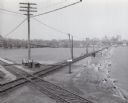
| Date: | 1955 |
|---|---|
| Description: | Elevated view of the Milwaukee Road and Chicago & Northwestern Railway crossing on Monona Bay, the site of the old MX tower. |

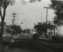
| Date: | 1955 |
|---|---|
| Description: | East Washington Avenue near Union Corners when first reopened after widening in 1955. Several vehicles are on the road. |
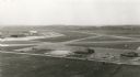
| Date: | 1955 |
|---|---|
| Description: | An aerial view at Truax Field showing the Municipal Airport Administration Building. |

| Date: | 1955 |
|---|---|
| Description: | View of the Wisconsin State Capitol from the intersection of Regent Street and West Washington Avenue. |

| Date: | 1955 |
|---|---|
| Description: | Slightly elevated view of East Washington Avenue at Union Corners (Milwaukee Street & North Street) when it first opened after its expansion. |

| Date: | 1955 |
|---|---|
| Description: | State patrol officers line up beside their patrol cars at Old District 1 State Patrol Field Headquarters on Highway 12. They appear to be receiving instruc... |

| Date: | 1955 |
|---|---|
| Description: | An aerial view of Middleton. In the foreground is a baseball field, and beyond are houses, woods, fields, and Lake Mendota. |

| Date: | 1955 |
|---|---|
| Description: | Lewis Arms is seated on his motorcycle with Craig Arms sitting in front of him and Lewis Arms, Jr. behind him. |
If you didn't find the material you searched for, our Library Reference Staff can help.
Call our reference desk at 608-264-6535 or email us at:


