Filter: Categories of Wisconsin Historical Images
Filter: FULL_DATE of 1955
Filter: Subject of transportation
Filter: Type of Photograph
Filter: Categories of Wisconsin Historical Images
Filter: FULL_DATE of 1955
Filter: Subject of transportation
Filter: Type of Photograph
| Date: | 1955 |
|---|---|
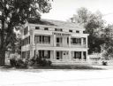
| Description: | Front view of the Wade House. The Wade House, one of the earliest stagecoach inns in Wisconsin, was built between 1847 and 1851 by Sylvanus Wade. It became... |

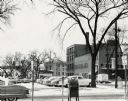
| Date: | 1955 |
|---|---|
| Description: | Exterior view of Central High School with cars parked in front. |

| Date: | 1955 |
|---|---|
| Description: | Chicago and Northwestern Railroad (CN&W) tracks between Brearly and Ingersoll Streets. |
| Date: | 1955 |
|---|---|
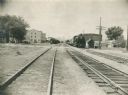
| Description: | Chicago and North Western Railroad (CN&W) tracks between Brearly and Ingersoll Streets. |

| Date: | 1955 |
|---|---|
| Description: | Aerial view of the central traffic loop and Johnson Street expressway. |

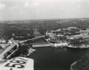
| Date: | 1955 |
|---|---|
| Description: | Aerial view of the Illinois central route. The UW Fieldhouse is visible in the lower right of the image. |
| Date: | 1955 |
|---|---|
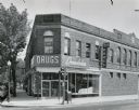
| Description: | The Rennebohm Drug Store #5, located at 2000 Atwood Avenue, Schenk's Corners from 1952-1961. It was previously located at 1951 Winnebago Street. This store... |

| Date: | 1955 |
|---|---|
| Description: | Elevated view of Capitol Square, looking northwest up Carroll Street at its intersection with Main Street. |
| Date: | 1955 |
|---|---|
| Description: | West Doty Street, from Monona Avenue looking toward South Carroll Street, showing the back side of Madison Newspapers, Inc. The building was added on to in... |
| Date: | 1955 |
|---|---|
| Description: | Aerial view of Wisconsin Dells. The wing of the airplane is in the left foreground. |

| Date: | 1955 |
|---|---|
| Description: | View across street towards the Kaukauna Public Library. |

| Date: | 1955 |
|---|---|
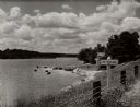
| Description: | Aerial view of river and town from a military airplane. |

| Date: | 1955 |
|---|---|
| Description: | Aerial view of La Crosse, with Onalaska in the background. The highway is U.S. Highway 53 and the State Highway 35. |
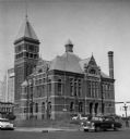
| Date: | 1955 |
|---|---|
| Description: | View across street towards the Marathon County Court House. |

| Date: | 1955 |
|---|---|
| Description: | Aerial view of Mineral Point showing State Highway 23-39 under construction. |

| Date: | 1955 |
|---|---|
| Description: | An aerial view of Mineral Point showing the construction of State Highway 23-39. |
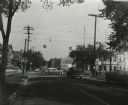
| Date: | 1955 |
|---|---|
| Description: | The intersection of Johnson and Broom Streets. |

| Date: | 1955 |
|---|---|
| Description: | A public bus crosses the bridge over a ravine on Lake Mendota Drive in Shorewood, looking east. |
If you didn't find the material you searched for, our Library Reference Staff can help.
Call our reference desk at 608-264-6535 or email us at: