Filter: Categories of Wisconsin Historical Images
Filter: FULL_DATE of 1955
Filter: Subject of roads
Filter: Categories of Wisconsin Historical Images
Filter: FULL_DATE of 1955
Filter: Subject of roads

| Date: | 1955 |
|---|---|
| Description: | Aerial view of Midvale neighborhood under construction near Madison's southwestern city limits. The view is focused on the area bounded by Tokay Boulevard,... |

| Date: | 1955 |
|---|---|
| Description: | Air view of University Avenue at Midvale Boulevard. |

| Date: | 1955 |
|---|---|
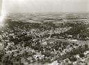
| Description: | Aerial view of Cross Plains, with countryside surrounding and hills on the horizon. |

| Date: | 1955 |
|---|---|
| Description: | Aerial view of Atwood Avenue, looking west towards Winnebago Street and "Schenk's Corners." |
| Date: | 1955 |
|---|---|
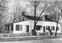
| Description: | View of Tank Cottage. The cottage was built in 1776 by Joseph Roi, a fur trader, who lived in it until 1805 when it was purchased by Jacques Porlier. Later... |
| Date: | 1955 |
|---|---|
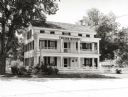
| Description: | Front view of the Wade House. The Wade House, one of the earliest stagecoach inns in Wisconsin, was built between 1847 and 1851 by Sylvanus Wade. It became... |

| Date: | 1955 |
|---|---|
| Description: | Aerial view of the central traffic loop and Johnson Street expressway. |

| Date: | 1955 |
|---|---|
| Description: | Aerial view of the Illinois central route. The UW Fieldhouse is visible in the lower right of the image. |

| Date: | 1955 |
|---|---|
| Description: | Elevated view of Capitol Square, looking northwest up Carroll Street at its intersection with Main Street. |
| Date: | 1955 |
|---|---|
| Description: | West Doty Street, from Monona Avenue looking toward South Carroll Street, showing the back side of Madison Newspapers, Inc. The building was added on to in... |

| Date: | 1955 |
|---|---|
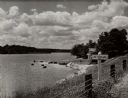
| Description: | Aerial view of river and town from a military airplane. |

| Date: | 1955 |
|---|---|
| Description: | View down Monona Avenue, which is now Martin Luther King, Jr. Boulevard, toward Lake Monona. |

| Date: | 1955 |
|---|---|
| Description: | A view looking northeast along Main Street from near its intersection with Monona Avenue on Capitol Square. |

| Date: | 1955 |
|---|---|
| Description: | Midvale Avenue and Odana Boulevard. |

| Date: | 1955 |
|---|---|
| Description: | Blacktopping a new Madison residential street. Construction of the ranch-style houses in the background is almost complete. |

| Date: | 1955 |
|---|---|
| Description: | East Washington Avenue near Union Corners when first reopened after widening in 1955. Several vehicles are on the road. |

| Date: | 1955 |
|---|---|
| Description: | Elevated view looking west at Washington School, located at 217 North Broom Street. From the early 1940's until its demolition in 1957, the school was used... |

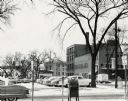
| Date: | 1955 |
|---|---|
| Description: | View of the Wisconsin State Capitol from the intersection of Regent Street and West Washington Avenue. |
If you didn't find the material you searched for, our Library Reference Staff can help.
Call our reference desk at 608-264-6535 or email us at: