 Filter: Categories of Wisconsin Historical Images
Filter: FULL_DATE of 1955
Filter: Subject of rivers
Filter: Categories of Wisconsin Historical Images
Filter: FULL_DATE of 1955
Filter: Subject of rivers

| Date: | 1955 |
|---|---|
| Description: | Artist's conception of ancient village of Aztalan, fortified with high walls surrounding it. |

| Date: | 1955 |
|---|---|
| Description: | Aerial view of town, with the Baraboo River. |

| Date: | 1955 |
|---|---|
| Description: | Aerial view of river and its surrounding landscape. |
| Date: | 1955 |
|---|---|
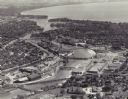
| Description: | Aerial view of "the island" with the Marathon Corporation paper mills. The Fox River flowing out of Lake Winnebago separates the two cities, Neenah and Men... |
| Date: | 1955 |
|---|---|
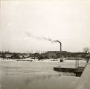
| Description: | View from Oshkosh Avenue across icy river towards the Pluswood factory in the distance. |
| Date: | 1955 |
|---|---|
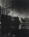
| Description: | Buildings and smokestacks along a riverfront. Sky darkened by the smoke. |
| Date: | 1955 |
|---|---|
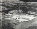
| Description: | Aerial view of Valley Fair Mall, with a residential area beyond it on both sides of a river, all surrounded by trees and farmland. |
| Date: | 1955 |
|---|---|
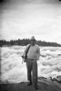
| Description: | Sigurd Olson, wearing his characteristic attire, on a trip on the Upper Churchill River. |

| Date: | 1955 |
|---|---|
| Description: | This 1950s tourist brochure features a map of Burnett County, Wisconsin, and northern Polk County which shows highways and roads, railroads, landmarks, and... |
| Date: | 1955 |
|---|---|
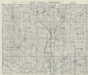
| Description: | This cadastral map shows highways, land owners, railroads, and rivers. |

| Date: | 1955 |
|---|---|
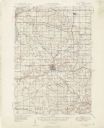
| Description: | This map shows roads, trails, county lines, town borders, section lines, railroads, rivers, lakes, and Lake Michigan on the far right. The bottom margin in... |

| Date: | 1955 |
|---|---|
| Description: | This map shows roads, golf courses, airports, fire towers, schools, camp grounds, rivers, streams, lakes, and railroads. The right margin of the map includ... |
| Date: | 1955 |
|---|---|
| Description: | This set of 32 maps and an index show the (then) proposed route of the Wisconsin Turnpike. The index shows the entire route of the turnpike, and the major ... |
| Date: | 1955 |
|---|---|
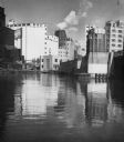
| Description: | Industries along the Milwaukee River, one of which is the Schlitz Brewery. |
| Date: | 1955 |
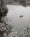
|---|---|
| Description: | Elevated view from shoreline towards two men motoring out onto the Menomonee River in the spring. |
If you didn't find the material you searched for, our Library Reference Staff can help.
Call our reference desk at 608-264-6535 or email us at:


