Filter: Categories of Wisconsin Historical Images
Filter: FULL_DATE of 1955
Filter: Subject of cities and towns
Filter: Subject of intellectual life
Filter: Categories of Wisconsin Historical Images
Filter: FULL_DATE of 1955
Filter: Subject of cities and towns
Filter: Subject of intellectual life

| Date: | 1955 |
|---|---|
| Description: | Aerial view of Midvale neighborhood under construction near Madison's southwestern city limits. The view is focused on the area bounded by Tokay Boulevard,... |

| Date: | 1955 |
|---|---|
| Description: | Artist's conception of ancient village of Aztalan, fortified with high walls surrounding it. |

| Date: | 1955 |
|---|---|
| Description: | Aerial view of town, with the Baraboo River. |

| Date: | 1955 |
|---|---|
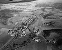
| Description: | Aerial view of Cross Plains, with countryside surrounding and hills on the horizon. |

| Date: | 1955 |
|---|---|
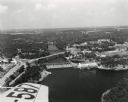
| Description: | An air view of Madison's downtown area with the Wisconsin State Capitol and new State Office Buildings. |

| Date: | 1955 |
|---|---|
| Description: | Aerial view of Atwood Avenue, looking west towards Winnebago Street and "Schenk's Corners." |

| Date: | 1955 |
|---|---|
| Description: | Aerial view of river and its surrounding landscape. |

| Date: | 1955 |
|---|---|
| Description: | Aerial view of the central traffic loop and Johnson Street expressway. |
| Date: | 1955 |
|---|---|
| Description: | West Doty Street, from Monona Avenue looking toward South Carroll Street, showing the back side of Madison Newspapers, Inc. The building was added on to in... |
| Date: | 1955 |
|---|---|
| Description: | Aerial view of Wisconsin Dells. The wing of the airplane is in the left foreground. |

| Date: | 1955 |
|---|---|
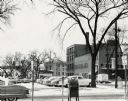
| Description: | View across street towards the Kaukauna Public Library. |

| Date: | 1955 |
|---|---|
| Description: | Aerial view of river and town from a military airplane. |

| Date: | 1955 |
|---|---|
| Description: | Aerial view of La Crosse, with Onalaska in the background. The highway is U.S. Highway 53 and the State Highway 35. |
| Date: | 1955 |
|---|---|
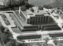
| Description: | Aerial view of the Forest Products Laboratory. |
If you didn't find the material you searched for, our Library Reference Staff can help.
Call our reference desk at 608-264-6535 or email us at: