 Filter: Categories of Wisconsin Historical Images
Filter: FULL_DATE of 1955
Filter: Community of Madison
Filter: Subject of transportation
Filter: Categories of Wisconsin Historical Images
Filter: FULL_DATE of 1955
Filter: Community of Madison
Filter: Subject of transportation
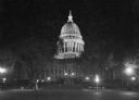
| Date: | 1955 |
|---|---|
| Description: | A nighttime view of the Wisconsin State Capitol as seen from Monona Avenue (South Wisconsin Avenue until December 1, 1877; Martin Luther King Jr. Boulevard... |

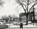
| Date: | 1955 |
|---|---|
| Description: | Aerial view of Midvale neighborhood under construction near Madison's southwestern city limits. The view is focused on the area bounded by Tokay Boulevard,... |
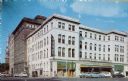
| Date: | 1955 |
|---|---|
| Description: | View of downtown Madison's Park Hotel. The Prescription Pharmacy also occupies a portion of the ground floor. |
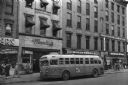
| Date: | 1955 |
|---|---|
| Description: | Bus traveling down Mifflin Street on Capitol Square. Moseleys, Woldenbergs and Walgreen's Drugs are on the right. |

| Date: | 1955 |
|---|---|
| Description: | Air view of University Avenue at Midvale Boulevard. |

| Date: | 1955 |
|---|---|
| Description: | An air view of Madison's downtown area with the Wisconsin State Capitol and new State Office Buildings. |

| Date: | 1955 |
|---|---|
| Description: | Aerial view of Atwood Avenue, looking west towards Winnebago Street and "Schenk's Corners." |

| Date: | 1955 |
|---|---|
| Description: | Exterior view of Central High School with cars parked in front. |

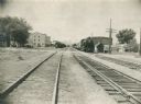
| Date: | 1955 |
|---|---|
| Description: | Chicago and Northwestern Railroad (CN&W) tracks between Brearly and Ingersoll Streets. |
| Date: | 1955 |
|---|---|
| Description: | Chicago and North Western Railroad (CN&W) tracks between Brearly and Ingersoll Streets. |

| Date: | 1955 |
|---|---|
| Description: | Aerial view of the central traffic loop and Johnson Street expressway. |

| Date: | 1955 |
|---|---|
| Description: | Aerial view of the Illinois central route. The UW Fieldhouse is visible in the lower right of the image. |
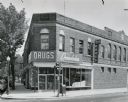
| Date: | 1955 |
|---|---|
| Description: | The Rennebohm Drug Store #5, located at 2000 Atwood Avenue, Schenk's Corners from 1952-1961. It was previously located at 1951 Winnebago Street. This store... |

| Date: | 1955 |
|---|---|
| Description: | Elevated view of Capitol Square, looking northwest up Carroll Street at its intersection with Main Street. |
| Date: | 1955 |
|---|---|
| Description: | West Doty Street, from Monona Avenue looking toward South Carroll Street, showing the back side of Madison Newspapers, Inc. The building was added on to in... |
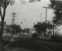
| Date: | 1955 |
|---|---|
| Description: | The intersection of Johnson and Broom Streets. |

| Date: | 1955 |
|---|---|
| Description: | A public bus crosses the bridge over a ravine on Lake Mendota Drive in Shorewood, looking east. |

| Date: | 1955 |
|---|---|
| Description: | Bridge over a ravine on Lake Mendota Drive in Shorewood Hills, looking west. |
If you didn't find the material you searched for, our Library Reference Staff can help.
Call our reference desk at 608-264-6535 or email us at:

