 Filter: Categories of Wisconsin Historical Images
Filter: FULL_DATE of 1955
Filter: Type of Map or Atlas
Filter: Subject of streets
Filter: Categories of Wisconsin Historical Images
Filter: FULL_DATE of 1955
Filter: Type of Map or Atlas
Filter: Subject of streets

| Date: | 1955 |
|---|---|
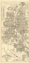
| Description: | Bottom of the map reads: "PARKING AREA STUDY MILWAUKEE COUNTY ZOOLOGICAL GARDEN SCALE 1"=200" APRIL 21, 1955 TOTAL PARKING AREA - 3736 CARS 31.1 acres". Th... |
| Date: | 1955 |
|---|---|
| Description: | This map of Wausau distributed by the Wausau Chamber of Commerce was originally published in July of 1940 and shows the Wisconsin River. The map includes a... |

| Date: | 1955 |
|---|---|
| Description: | This blue line print shows streets, fair grounds, schools, parks, and a cemetery. Streets, points of interest, and Lake Marinuka are labeled. The middle le... |

| Date: | 1955 |
|---|---|
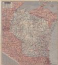
| Description: | This colored road map shows automobile roads in Wisconsin as well as portions of nearby states. Information on the quality and type of any road shown (U.S.... |
| Date: | 1955 |
|---|---|
| Description: | This colored road map shows automobile roads in Wisconsin as well as portions of nearby states. Information on the quality and type of any road shown (pave... |
| Date: | 1955 |
|---|---|
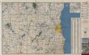
| Description: | This colored road map shows automobile roads in Southeastern Wisconsin on the front and Milwaukee on the back. On the front side of the map, information on... |
If you didn't find the material you searched for, our Library Reference Staff can help.
Call our reference desk at 608-264-6535 or email us at: