 Filter: Categories of Wisconsin Historical Images
Filter: FULL_DATE of 1954
Filter: Subject of lakes
Filter: Categories of Wisconsin Historical Images
Filter: FULL_DATE of 1954
Filter: Subject of lakes
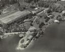
| Date: | 1954 |
|---|---|
| Description: | Aerial view of Kraftwood, the rural estate of the Kraft family of the Kraft Foods Co. of Wisconsin. The estate is situated on a peninsula jutting into Ente... |

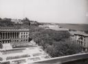
| Date: | 1954 |
|---|---|
| Description: | Looking northwest down Wisconsin Avenue from the Wisconsin State Capitol dome. Mifflin Street is visible in the foreground, while in the center of the phot... |
| Date: | 1954 |
|---|---|
| Description: | View from roof top of lower campus at the University of Wisconsin-Madison. Wisconsin Historical Society is in left foreground and Science Hall is visible b... |
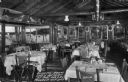
| Date: | 1954 |
|---|---|
| Description: | View of the dining room which shows tables set for a meal. Large picture windows have views of the lake and woods surrounding the resort, and above the win... |
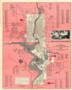
| Date: | 1954 |
|---|---|
| Description: | This map of Wausau is pink, red, gray, and white. The map includes indexes of streets, industries, and community buildings and features a photograph of the... |
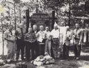
| Date: | 1954 |
|---|---|
| Description: | Ten men are standing in a row in front of a sign marking the 25th anniversary of the Eagle Scout Forestry Camp. They are each holding an Eagle Scout trophy... |

| Date: | 1954 |
|---|---|
| Description: | Aerial view of the west side of Madison showing newly constructed homes and homes under construction featured in the Parade of Homes. The main road through... |

| Date: | 1954 |
|---|---|
| Description: | This map shows the location of Catholic churches, missions, and shrines. The map is color coded and includes a key in the bottom left corner. The back of t... |

| Date: | 1954 |
|---|---|
| Description: | Elevated view from the Wisconsin State Capitol looking west up State Street toward the University of Wisconsin. Frozen Lake Monona is on the right. |
| Date: | 1954 |
|---|---|
| Description: | This photocopy map shows a early sketch of the settlement Southport. Rivers, lakes, other settlements, county boundaries, and roads are labeled. A portion ... |
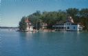
| Date: | 1954 |
|---|---|
| Description: | Kodachrome print of a lakeside hotel. Text on reverse reads: "Hotel Camp Brosius on beautiful Elkhart Lake. Dining room, lounge, boat area, and round house... |
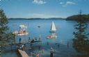
| Date: | 1954 |
|---|---|
| Description: | Elevated view towards dock, and a diving platform at Camp Brosius. A sailboat, rowboat and canoes are in the lake. Several people are swimming or standing ... |
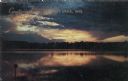
| Date: | 1954 |
|---|---|
| Description: | Sunset over Elkhart Lake, with the calm lake reflecting the orange sky. Caption reads: "Greetings from Elkhart Lake, Wis." Text on reverse reads: "Sunset a... |
| Date: | 1954 |
|---|---|
| Description: | This map is designed to help Catholic tourists in Wisconsin find Catholic churches and missions. On the front side, a road map of Wisconsin showing the loc... |
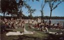
| Date: | 1954 |
|---|---|
| Description: | Color postcard view of a crowded bathing beach at Lake Wingra. |
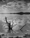
| Date: | 1954 |
|---|---|
| Description: | Wood from a dead tree on the Lake Wisconsin shoreline protruding from the water, and silhouetted against the reflection of a dramatic sky. The far shore is... |
If you didn't find the material you searched for, our Library Reference Staff can help.
Call our reference desk at 608-264-6535 or email us at: