 Filter: Categories of Wisconsin Historical Images
Filter: FULL_DATE of 1953
Filter: Subject of transportation
Filter: Community of Madison
Filter: Categories of Wisconsin Historical Images
Filter: FULL_DATE of 1953
Filter: Subject of transportation
Filter: Community of Madison

| Date: | 1953 |
|---|---|
| Description: | Aerial view looking southeast over Madison's near east side. The Eagles Club at 1236 Jenifer Street / 1221 Williamson Street is under construction in the ... |

| Date: | 1953 |
|---|---|
| Description: | View looking northeast along Mifflin Street near its intersection with Carroll Street on the Capitol Square. |

| Date: | 1953 |
|---|---|
| Description: | This map shows local streets, roads, highways, Middleton, Monona, Lake Wingra, Lake Monona, Lake Mendota, and an inset map that shows city parking areas. A... |

| Date: | 1953 |
|---|---|
| Description: | Exterior view from sidewalk of City Hall, located at the intersection of West Mifflin Street and Wisconsin Avenue. The Parkway Theatre, featuring the films... |

| Date: | 1953 |
|---|---|
| Description: | This map shows locations of State Medical Society, nine medical facilities, two University of Wisconsin buildings, four transportation centers, and five ho... |
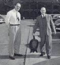
| Date: | 1953 |
|---|---|
| Description: | Two executives standing in a parking lot behind the Gisholt Machine Company. The man on the left is standing with his hands behind his back. The man on th... |
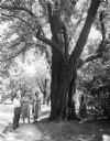
| Date: | 1953 |
|---|---|
| Description: | A man and three women standing at the base of a large tree, identified as the Muir Locust. The tree grew along Observatory Drive on the University of Wisco... |
If you didn't find the material you searched for, our Library Reference Staff can help.
Call our reference desk at 608-264-6535 or email us at: