 Filter: Categories of Wisconsin Historical Images
Filter: FULL_DATE of 1952
Filter: Subject of roads
Filter: Categories of Wisconsin Historical Images
Filter: FULL_DATE of 1952
Filter: Subject of roads

| Date: | 1952 |
|---|---|
| Description: | Color photograph of an International R-110 Truck with pickup body and "Ad-A-Rak" with stock extensions. The truck is on a rural highway. |
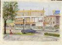
| Date: | 1952 |
|---|---|
| Description: | Watercolor painting of a Wolff-Kubly & Hirsig building (the site of the current Wisconsin Historical Museum) under construction. |
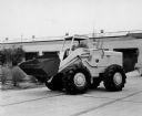
| Date: | 1952 |
|---|---|
| Description: | The Hough HW Payloader was built by Frank G. Hough Company of Libertyville, Illinois. The construction equipment manufacturer was purchased by Internationa... |

| Date: | 1952 |
|---|---|
| Description: | Elevated view down Wells Street from the first Wisconsin National Bank Building. Commerce office on lower left. |

| Date: | 1952 |
|---|---|
| Description: | Front view looking towarsd a man under an umbrella using a Farmall Super C tractor outfitted with a C-254 cultivator to work in a field. Another man on a t... |
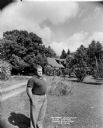
| Date: | 1952 |
|---|---|
| Description: | Wisconsin author August Derleth standing in front of his Sauk City home, "the Place of the Hawks." |
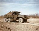
| Date: | 1952 |
|---|---|
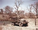
| Description: | Color photograph of an engineer construction battalion with an M-51 dump truck. The battalion used the truck to transport topsoil along a dirt road at Fort... |

| Date: | 1952 |
|---|---|
| Description: | View towards of men using an M-61 to spread asphalt at Wolters Air Force Base. A building, possibly a church or chapel, stands in the background along the ... |
| Date: | 1952 |
|---|---|
| Description: | Color photograph of an M-139 truck transporting members of a bridge-building unit and construction materials to the bank of a river in a wooded area. The s... |
| Date: | 1952 |
|---|---|
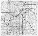
| Description: | View of the plat map of Theresa, copyright by General Map Company, 1952. |

| Date: | 1952 |
|---|---|
| Description: | This 1952 map shows the trails, roads, and railroads through the counties of Ashland, Bayfield, Sawyer, Price, Iron, and Vilas. Also shown are lakes, river... |

| Date: | 1952 |
|---|---|
| Description: | This 1952 map of the northern parts of Bayfield and Douglas counties, Wisconsin, shows points established by E.T. Sweet in 1877, road points confirmed by S... |

| Date: | 1952 |
|---|---|
| Description: | This map of the northern parts of the Chequamegon Bay area in Bayfield and Ashland counties, Wisconsin, shows trails, roads, railroads, stations, the towns... |

| Date: | 1952 |
|---|---|
| Description: | This Wisconsin Conservation Dept. map shows sections, roads, rivers, and lakes in the Town of Cloverland, Vilas County, Wisconsin as of February, 1952. It ... |

| Date: | 1952 |
|---|---|
| Description: | This Wisconsin Conservation Dept. map shows sections, roads, rivers, and lakes in the Town of Presque Isle, Vilas County, Wisconsin as of March 1953. It do... |

| Date: | 1952 |
|---|---|
| Description: | Map shows roads, highways, railroads, parks, city buildings, schools, cemeteries, city limits, and the Fox River. The map is indexed by street name, street... |

| Date: | 1952 |
|---|---|
| Description: | Three-quarter view from the front left side of a man sitting in the driver's seat of an International L-112 Travelall. |

| Date: | 1952 |
|---|---|
| Description: | This map of Beaver Dam shows state trunk highway system, county trunk highway system, town roads, rivers, and Beaver Dam Lake and includes an additional at... |

| Date: | 1952 |
|---|---|
| Description: | This colorful map of Beloit shows roads, railroads, rivers, creeks, business districts, industrial areas, and parks and recreation areas. The map includes ... |

| Date: | 1952 |
|---|---|
| Description: | This map shows roads, foot and canoe trails, railroads, resorts, lookout towers, camps, national and state forests, Indian reservation, and types of fish i... |
If you didn't find the material you searched for, our Library Reference Staff can help.
Call our reference desk at 608-264-6535 or email us at: