Filter: Categories of Wisconsin Historical Images
Filter: FULL_DATE of 1952
Filter: Subject of land
Filter: Categories of Wisconsin Historical Images
Filter: FULL_DATE of 1952
Filter: Subject of land

| Date: | 1952 |
|---|---|
| Description: | Aerial view of a North Central Airlines DC-3 airplane flying over the Madison isthmus. Clearly visible are the Wisconsin State Capitol, the 1 West Wilson S... |
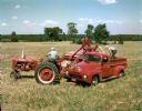
| Date: | 1952 |
|---|---|
| Description: | Farmers harvesting grain with a McCormick Farmall Super C tractor, combine (harvester-thresher) and International LM-120 truck. The McCormick Farmall Super... |
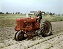
| Date: | 1952 |
|---|---|
| Description: | Color photograph of a man operating a McCormick Farmall Super M with rotary cultivator. |
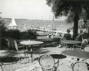
| Date: | 1952 |
|---|---|
| Description: | University of Wisconsin-Madison Memorial Union Terrace with Lake Mendota and sailboats in the background. |
| Date: | 1952 |
|---|---|
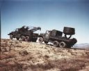
| Description: | Color photograph of an M-40 Marine Corps vehicle equipped with a wrecker body towing a searchlight truck up a sandy hill. Mountains are in the far backgrou... |
| Date: | 1952 |
|---|---|
| Description: | Color photograph of an M-40 Marine Corps vehicle equipped with a wrecker body towing a searchlight truck up a hill in an area of brush. Mountains and pastu... |
| Date: | 1952 |
|---|---|
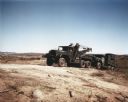
| Description: | Color photograph of M-41 and M-54 cargo vehicles servicing and transporting 155-mm howitzers with 10-gun crews. The trucks belonged to the 73rd Armored Art... |
| Date: | 1952 |
|---|---|
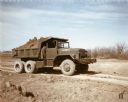
| Description: | Color photograph of an engineer construction battalion with an M-51 dump truck. The battalion used the truck to transport topsoil along a dirt road at Fort... |

| Date: | 1952 |
|---|---|
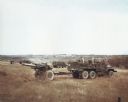
| Description: | Color photograph of members of the 73rd Armored Field Artillery using an M-62 wrecker to remove a damaged truck from a field at Fort Hood. The specificatio... |
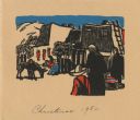
| Date: | 1952 |
|---|---|
| Description: | Holiday card with a scene of a village in New Mexico. Adobe dwellings with hills, fences, a ladder, trees and a burro can be seen in the background. Six fi... |

| Date: | 1952 |
|---|---|
| Description: | The famous Dells of the Wisconsin River. A souvenir map embellished with bits of history and points of interest. |
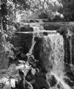
| Date: | 1952 |
|---|---|
| Description: | "This waterfall is located on Hocheim Road southwest of Theresa." |

| Date: | 1952 |
|---|---|
| Description: | This 1952 map shows the trails, roads, and railroads through the counties of Ashland, Bayfield, Sawyer, Price, Iron, and Vilas. Also shown are lakes, river... |

| Date: | 1952 |
|---|---|
| Description: | This 1952 map of the northern parts of Bayfield and Douglas counties, Wisconsin, shows points established by E.T. Sweet in 1877, road points confirmed by S... |

| Date: | 1952 |
|---|---|
| Description: | This map of the northern parts of the Chequamegon Bay area in Bayfield and Ashland counties, Wisconsin, shows trails, roads, railroads, stations, the towns... |

| Date: | 1952 |
|---|---|
| Description: | This Wisconsin Conservation Dept. map shows sections, roads, rivers, and lakes in the Town of Cloverland, Vilas County, Wisconsin as of February, 1952. It ... |

| Date: | 1952 |
|---|---|
| Description: | This Wisconsin Conservation Dept. map shows sections, roads, rivers, and lakes in the Town of Presque Isle, Vilas County, Wisconsin as of March 1953. It do... |
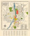
| Date: | 1952 |
|---|---|
| Description: | This colorful map of Beloit shows roads, railroads, rivers, creeks, business districts, industrial areas, and parks and recreation areas. The map includes ... |

| Date: | 1952 |
|---|---|
| Description: | Outdoor portrait of a uniformed man, probably John Scott. Behind him is a boat on a body of water, and on the opposite shorelineis a town and hillside. Ta... |
If you didn't find the material you searched for, our Library Reference Staff can help.
Call our reference desk at 608-264-6535 or email us at: