Filter: Categories of Wisconsin Historical Images
Filter: FULL_DATE of 1952
Filter: Subject of cities and towns
Filter: Year of 1900-1999
Filter: Categories of Wisconsin Historical Images
Filter: FULL_DATE of 1952
Filter: Subject of cities and towns
Filter: Year of 1900-1999
| Date: | 1952 |
|---|---|
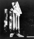
| Description: | Night view of entrance to Wayland Hall, built in 1855, at Wayland Junior College. |
| Date: | 1952 |
|---|---|
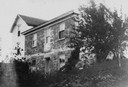
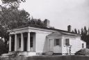
| Description: | Berry Haney house, built in about 1841 or 1842. The frame parts of the house are later additions. |
| Date: | 1952 |
|---|---|
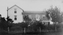
| Description: | Berry Haney house obscured by some trees and plants. The house was built in about 1841 or 1842. The frame parts are later additions. |

| Date: | 1952 |
|---|---|
| Description: | View towards the front and left side of the church. Caption reads: "First Presbyterian Church, Weyauwega, Wis." |
| Date: | 1952 |
|---|---|
| Description: | A residence at 930 East Gorham Street, on the site once occupied by the Walker "castle". |
| Date: | 1952 |
|---|---|
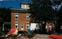
| Description: | Exterior view of the Republican House Restaurant with patio tables and umbrellas set up outside. |

| Date: | 1952 |
|---|---|
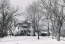
| Description: | View of the Mendota grade school. Snow is on the ground. |
| Date: | 1952 |
|---|---|
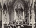
| Description: | Elevated view towards the altar at St. Mary's Church on the occasion of Donald Schleuter's wedding. |
| Date: | 1952 |
|---|---|
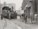
| Description: | Members of the United Packinghouse Workers Local 80 picketing the Campbell Soup Company plant. The union had walked out as a result of wage, union shop, an... |

| Date: | 1952 |
|---|---|
| Description: | Riverside Park, as seen from the south side of the Fox River. A section of the Main street bridge can be seen at the left. |

| Date: | 1952 |
|---|---|
| Description: | The Oshkosh Public Museum. Occupies the former home of Edgar Sawyer, lumberman and businessman. It was built in 1908 and became a museum in 1924. This muse... |
| Date: | 1952 |
|---|---|
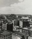
| Description: | Elevated view down Wells Street from the first Wisconsin National Bank Building. Commerce office on lower left. |
| Date: | 1952 |
|---|---|
| Description: | Benjamin Church House in Estabrook Park, operated as a museum by the Milwaukee County Historical Society. House is at a three-quarter angle to the viewer. ... |

| Date: | 1952 |
|---|---|
| Description: | Bells of the Carillon Tower on the University of Wisconsin-Madison campus. |

| Date: | 1952 |
|---|---|
| Description: | This 1952 map of the northern parts of Bayfield and Douglas counties, Wisconsin, shows points established by E.T. Sweet in 1877, road points confirmed by S... |

| Date: | 1952 |
|---|---|
| Description: | This map of the northern parts of the Chequamegon Bay area in Bayfield and Ashland counties, Wisconsin, shows trails, roads, railroads, stations, the towns... |

| Date: | 1952 |
|---|---|
| Description: | Map shows roads, highways, railroads, parks, city buildings, schools, cemeteries, city limits, and the Fox River. The map is indexed by street name, street... |

| Date: | 1952 |
|---|---|
| Description: | View across street towards the Ephraim Village Hall. Automobiles are parked on both sides of the street. Text on reverse reads: "A view of Ephraim's pic... |
| Date: | 1952 |
|---|---|
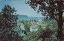
| Description: | Kodachrome reproduction of the view over the rooftops of Ephraim towards Eagle Bay. Text on reverse reads: "Portraying the beauty and charm of picturesq... |
If you didn't find the material you searched for, our Library Reference Staff can help.
Call our reference desk at 608-264-6535 or email us at: