 Filter: Categories of Wisconsin Historical Images
Filter: FULL_DATE of 1952
Filter: Subject of cities and towns
Filter: Subject of transportation
Filter: Categories of Wisconsin Historical Images
Filter: FULL_DATE of 1952
Filter: Subject of cities and towns
Filter: Subject of transportation

| Date: | 1952 |
|---|---|
| Description: | Aerial view of a North Central Airlines DC-3 airplane flying over the Madison isthmus. Clearly visible are the Wisconsin State Capitol, the 1 West Wilson S... |
| Date: | 1952 |
|---|---|
| Description: | Slightly elevated view of a parade on the Capitol Square, celebrating a visit by Adlai Stevenson, Democratic candidate for President. |
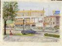
| Date: | 1952 |
|---|---|
| Description: | Watercolor painting of a Wolff-Kubly & Hirsig building (the site of the current Wisconsin Historical Museum) under construction. |
| Date: | 1952 |
|---|---|
| Description: | Exterior view across street towards the Washington House. The building was razed about 1952-1953. |
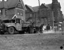
| Date: | 1952 |
|---|---|
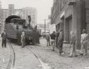
| Description: | Milwaukee streets department employees repair the intersection of Meinecke Avenue and 12th Street. Behind them, a Blatz truck is making a delivery to the ... |
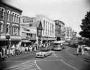
| Date: | 1952 |
|---|---|
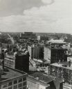
| Description: | An elevated view of the downtown section. |
| Date: | 1952 |
|---|---|
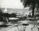
| Description: | University of Wisconsin-Madison Memorial Union Terrace with Lake Mendota and sailboats in the background. |
| Date: | 1952 |
|---|---|
| Description: | Members of the United Packinghouse Workers Local 80 picketing the Campbell Soup Company plant. The union had walked out as a result of wage, union shop, an... |

| Date: | 1952 |
|---|---|
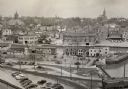
| Description: | Riverside Park, as seen from the south side of the Fox River. A section of the Main street bridge can be seen at the left. |
| Date: | 1952 |
|---|---|
| Description: | Elevated view down Wells Street from the first Wisconsin National Bank Building. Commerce office on lower left. |
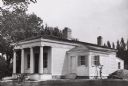
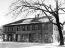
| Date: | 1952 |
|---|---|
| Description: | Benjamin Church House in Estabrook Park, operated as a museum by the Milwaukee County Historical Society. House is at a three-quarter angle to the viewer. ... |
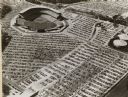
| Date: | 1952 |
|---|---|
| Description: | Home baseball park for the Milwaukee Braves baseball team. The field is on the upper left, with the rest of the image taken over by the full parking lots. |

| Date: | 1952 |
|---|---|
| Description: | Lewis Arms leans against a car with his arm around his family friend and neighbor John Berry, who he called "Pa Berry". |
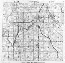
| Date: | 1952 |
|---|---|
| Description: | View of the plat map of Theresa, copyright by General Map Company, 1952. |

| Date: | 1952 |
|---|---|
| Description: | Employees of Hess Cooperage quarter log sections for barrel-making. The man standing in the middle of the image is Joe Hess. |

| Date: | 1952 |
|---|---|
| Description: | This 1952 map of the northern parts of Bayfield and Douglas counties, Wisconsin, shows points established by E.T. Sweet in 1877, road points confirmed by S... |

| Date: | 1952 |
|---|---|
| Description: | This map of the northern parts of the Chequamegon Bay area in Bayfield and Ashland counties, Wisconsin, shows trails, roads, railroads, stations, the towns... |

| Date: | 1952 |
|---|---|
| Description: | This Wisconsin Conservation Dept. map shows sections, roads, rivers, and lakes in the Town of Cloverland, Vilas County, Wisconsin as of February, 1952. It ... |

| Date: | 1952 |
|---|---|
| Description: | This Wisconsin Conservation Dept. map shows sections, roads, rivers, and lakes in the Town of Presque Isle, Vilas County, Wisconsin as of March 1953. It do... |

| Date: | 1952 |
|---|---|
| Description: | Map shows roads, highways, railroads, parks, city buildings, schools, cemeteries, city limits, and the Fox River. The map is indexed by street name, street... |
If you didn't find the material you searched for, our Library Reference Staff can help.
Call our reference desk at 608-264-6535 or email us at: