 Filter: Categories of Wisconsin Historical Images
Filter: FULL_DATE of 1943
Filter: Subject of streets
Filter: Categories of Wisconsin Historical Images
Filter: FULL_DATE of 1943
Filter: Subject of streets
| Date: | 1943 |
|---|---|
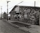
| Description: | Exterior of Albert Kaepernick Jr.'s McCormick-Deering farm equipment dealership. A poster in the front window reads: "Throw your scrap into the fight!". |

| Date: | 1943 |
|---|---|
| Description: | Exterior view of the McCormick branch office and showroom operated by "Cima-Wallut Machines Agricoles McCormick et Deering," and located at S.A. 80-82, Ave... |

| Date: | 1943 |
|---|---|
| Description: | Exterior view of International Harvester's general office for Argentina, located at Calle Chile 801, Buenos Aires, Argentina, South America. |

| Date: | 1943 |
|---|---|
| Description: | Exterior view of an International Harvester branch office operated by A/S International Harvester Company at Snorresgade 18-20, Copenhagen, S., Denmark. A ... |

| Date: | 1943 |
|---|---|
| Description: | Exterior view of an International Harvester general office at Paris. The office was operated by the Cima-Wallut Machines Agricoles McCormick et Deering, S.... |

| Date: | 1943 |
|---|---|
| Description: | Exterior view of the the International Harvester general office in New Zealand. The office was operated by the subsidiary International Harvester Company o... |

| Date: | 1943 |
|---|---|
| Description: | Elevated view of Wisconsin Avenue, looking east from Court of Honor. Caption reads: "Court of Honor, Looking East, Milwaukee, Wisconsin." |
| Date: | 1943 |
|---|---|
| Description: | Map shows the town of St. Catherine, Wisconsin, between Lake Street and Doty Street as it appeared on January 3, 1852. Map is situated facing north with La... |

| Date: | 1943 |
|---|---|
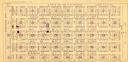
| Description: | This map of Sturgeon Bay shows section and quarter corners, ward divisions, government building locations, roads, and railroads. The map includes a legend ... |
| Date: | 1943 |
|---|---|
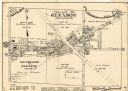
| Description: | This map of the Village of Gleason shows land ownership by name, local streets, railroads, churches, schools, and part of Prairie River. The bottom left of... |
| Date: | 1943 |
|---|---|
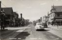
| Description: | Photographic postcard view looking north on Barnard Avenue from Packard Avenue. There are businesses, automobiles and pedestrians on both sides of the stre... |
If you didn't find the material you searched for, our Library Reference Staff can help.
Call our reference desk at 608-264-6535 or email us at: