 Filter: Categories of Wisconsin Historical Images
Filter: FULL_DATE of 1943
Filter: Subject of lakes
Filter: Categories of Wisconsin Historical Images
Filter: FULL_DATE of 1943
Filter: Subject of lakes

| Date: | 1943 |
|---|---|
| Description: | Shows Madison city limits with thick solid lines and ward districts with dotted lines. The wards are numbered, and points of interests and land marks are l... |
| Date: | 1943 |
|---|---|
| Description: | Map shows the town of St. Catherine, Wisconsin, between Lake Street and Doty Street as it appeared on January 3, 1852. Map is situated facing north with La... |

| Date: | 1943 |
|---|---|
| Description: | This map shows roads, trails, taverns, schools, golf, gas stations, campsites, resorts, and towers. The lower left of the map includes a legend. The map co... |

| Date: | 1943 |
|---|---|
| Description: | Photographic postcard view of a sailboat on Lake Geneva. A woman is standing on the deck. Caption reads: "Sailing — at College Camp, Wisconsin On Lak... |
| Date: | 1943 |
|---|---|
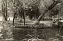
| Description: | View across outlet towards the park by Rock Lake. People are picnicking, children are on a swing set, and women are walking along a path. There is a rustic... |

| Date: | 1943 |
|---|---|
| Description: | Text on front reads: "Sockness Park, Rice Lake, Wis." A dirt road runs towards the lake, then curves to the left along the shoreline. Cottages, boathouses ... |
If you didn't find the material you searched for, our Library Reference Staff can help.
Call our reference desk at 608-264-6535 or email us at: