 Filter: Categories of Wisconsin Historical Images
Filter: FULL_DATE of 1943
Filter: Type of Map or Atlas
Filter: Subject of water
Filter: Year of 1900-1999
Filter: Categories of Wisconsin Historical Images
Filter: FULL_DATE of 1943
Filter: Type of Map or Atlas
Filter: Subject of water
Filter: Year of 1900-1999

| Date: | 1943 |
|---|---|
| Description: | This photocopy map shows inhabited farms, rivers, roads, and mills in the vicinity of Marathon City [and village of Edgar], including area between the Big ... |

| Date: | 1943 |
|---|---|
| Description: | This 1943 map of Door County, Wisconsin, identifies the post offices and rural routes in the county. Highways and roads, cities and villages, and rural res... |

| Date: | 1943 |
|---|---|
| Description: | Shows Madison city limits with thick solid lines and ward districts with dotted lines. The wards are numbered, and points of interests and land marks are l... |
| Date: | 1943 |
|---|---|
| Description: | Map shows the town of St. Catherine, Wisconsin, between Lake Street and Doty Street as it appeared on January 3, 1852. Map is situated facing north with La... |

| Date: | 1943 |
|---|---|
| Description: | This map of Sturgeon Bay shows section and quarter corners, ward divisions, government building locations, roads, and railroads. The map includes a legend ... |
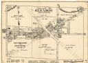
| Date: | 1943 |
|---|---|
| Description: | This map of the Village of Gleason shows land ownership by name, local streets, railroads, churches, schools, and part of Prairie River. The bottom left of... |

| Date: | 1943 |
|---|---|
| Description: | This map shows roads, trails, taverns, schools, golf, gas stations, campsites, resorts, and towers. The lower left of the map includes a legend. The map co... |
If you didn't find the material you searched for, our Library Reference Staff can help.
Call our reference desk at 608-264-6535 or email us at: