Filter: Categories of Wisconsin Historical Images
Filter: FULL_DATE of 1940
Filter: Subject of formations (geology)
Filter: Categories of Wisconsin Historical Images
Filter: FULL_DATE of 1940
Filter: Subject of formations (geology)
| Date: | 1940 |
|---|---|
| Description: | Big Manitou Falls with trees and observation area. |
| Date: | 1940 |
|---|---|
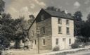
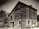
| Description: | A restored Cornish miner's house, called Polperro, on Shake Rag Street. The house was temporarily covered with siding, but after restoration the siding was... |
| Date: | 1940 |
|---|---|
| Description: | A woman demonstrating how Shake Rag Street got its name, with the restored Cornish miner's house, called Polperro, behind her. The house was temporarily co... |
| Date: | 1940 |
|---|---|
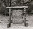
| Description: | The Mesas and Buttes historical marker in Mill Bluff State Park. The marker reads: "Mesas and Buttes. These so-called mounds with flat tops and cliffed sid... |
| Date: | 1940 |
|---|---|
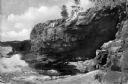
| Description: | A view of some caves at Peninsula State Park. |
| Date: | 1940 |
|---|---|
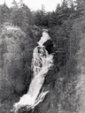
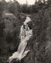
| Description: | Big Manitou Falls on the Black River. It is referred to as the "lower falls" in the park. This 165-foot waterfall is recognized as the highest in the state... |
| Date: | 1940 |
|---|---|
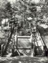
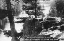
| Description: | Two rustic stairways leading down to the Bad River at Copper Falls State Park. At the bottom of the stairs is a sign telling the geological story of Copper... |
| Date: | 1940 |
|---|---|
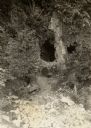
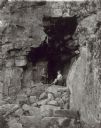
| Description: | A young boy and girl posed inside of the Elephant Cave in the east bluffs at Devil's Lake State Park. |
| Date: | 1940 |
|---|---|
| Description: | View of Anemone Cave and crashing waves, surrounded by coastal rock formations. |

| Date: | 1940 |
|---|---|
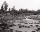
| Description: | Woman seated on flat rocks, watching rushing water of the Wolf River. |
| Date: | 1940 |
|---|---|
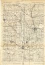
| Description: | This quadrangle collection of maps, meaning geological surveys, shows sections of central and northern Wisconsin. The maps include a quadrangle index map. ... |

| Date: | 1940 |
|---|---|
| Description: | Color postcard of a view across water towards the rocky banks of Lake Wissota. Caption reads: "Lake Wissota, Chippewa Falls, Wis." |

| Date: | 1940 |
|---|---|
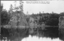
| Description: | Colored postcard of rocky bluffs and a park road in Irvine Park. |

| Date: | 1940 |
|---|---|
| Description: | Two women and a man (a fourth rider is hidden) on horseback are enjoying the view from a bluff in Devil's Lake State Park. The Devil's Doorway rock formati... |

| Date: | 1940 |
|---|---|
| Description: | An elevated view of the St. Croix River at Interstate Park. There is a boat with open sides, probably an excursion boat, going down the river, and rock for... |
| Date: | 1940 |
|---|---|
| Description: | Photographic postcard view across water towards rock formations along the St. Croix River in Interstate State Park. "Caption reads: "Angle Rock Bend on the... |
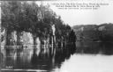
| Date: | 1940 |
|---|---|
| Description: | A retouched photographic postcard view across water towards rock formations along the St. Croix River in Interstate State Park. The caption reads: "LaCroix... |
| Date: | 1940 |
|---|---|
| Description: | Photographic postcard elevated view of the St. Croix River in Interstate State Park, with a large rock outcropping and pine trees in the foreground. Captio... |

| Date: | 1940 |
|---|---|
| Description: | A view from the top of Gibraltar Rock showing a portion of the bluff, left, and rolling fields and woodlands beyond. There is a pond or stream on the right... |
If you didn't find the material you searched for, our Library Reference Staff can help.
Call our reference desk at 608-264-6535 or email us at: