 Filter: Categories of Wisconsin Historical Images
Filter: FULL_DATE of 1939
Filter: Subject of parks
Filter: Categories of Wisconsin Historical Images
Filter: FULL_DATE of 1939
Filter: Subject of parks
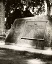
| Date: | 1939 |
|---|---|
| Description: | The Timothy Burns tablet in Burns Park, near Main Street. The tablet reads: "To perpetuate the record of the gift of Burns Park to La Crosse by Hon. Timoth... |

| Date: | 1939 |
|---|---|
| Description: | View of the Tower at Roselawn Memorial Park. |

| Date: | 1939 |
|---|---|
| Description: | View from the driver's seat of an International Metro truck, showing part of the steering wheel and a city street beyond. Automobiles are parked near the c... |

| Date: | 1939 |
|---|---|
| Description: | Visitors of Milwaukee's sixth annual Midsummer Festival. Men and women walk on the lakefront walkways. |
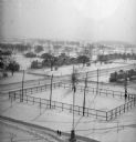
| Date: | 1939 |
|---|---|
| Description: | Elevated view of village with snow on the ground. A tennis court, flag pole, and pedestrians are visible in the foreground. Behind the tennis court are roa... |
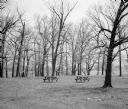
| Date: | 1939 |
|---|---|
| Description: | Two picnic tables in a clearing at picnic grove. |

| Date: | 1939 |
|---|---|
| Description: | Flag pole with limestone carving of women and men by Alonzo Hauser, who was appointed by the Farm Security Administration, at its base. The sculpture was b... |
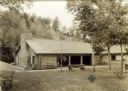
| Date: | 1939 |
|---|---|
| Description: | The shelter house at Copper Falls State Park. |

| Date: | 1939 |
|---|---|
| Description: | This nine-part map from the U.S. Bureau of Public Roads identifies federal and state highways in Wisconsin by pavement type. County, forest, park, and publ... |

| Date: | 1939 |
|---|---|
| Description: | This is a zoning map of Wauwatosa with a key of districts including agricultural, resident, business, commercial, and industrial. The map features labeled ... |

| Date: | 1939 |
|---|---|
| Description: | This illustrated map shows counties, highways, rivers, roads, present and proposed state parks and forests, proposed state parkways, proposed state monumen... |
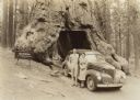
| Date: | 1939 |
|---|---|
| Description: | Edward J. Brumder and his wife, Marion Briggs Brumder, posing while leaning against a 1939 Studebaker Commander parked in front of the Wawona Tunnel Tree. ... |
If you didn't find the material you searched for, our Library Reference Staff can help.
Call our reference desk at 608-264-6535 or email us at: