 Filter: Categories of Wisconsin Historical Images
Filter: FULL_DATE of 1939
Filter: Subject of lakes
Filter: Categories of Wisconsin Historical Images
Filter: FULL_DATE of 1939
Filter: Subject of lakes
| Date: | 1939 |
|---|---|
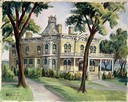
| Description: | The Benjamin Franklin Hopkins house, 142 East Gilman Street, built by Hopkins about 1850. The house was later owned by Dr. William Jacobs. The square bay ... |

| Date: | 1939 |
|---|---|
| Description: | The Fauerbach Brewery, with Lake Monona in the background. |
| Date: | 1939 |
|---|---|
| Description: | The proposed Mendota Lake Front Development Plan, William Kaeser, architect. |

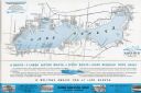
| Date: | 1939 |
|---|---|
| Description: | A color, pictorial map. Scale: 10 miles to the inch. Shows state parks and forests, proposed state parkways, proposed state monuments and memorials, nation... |

| Date: | 1939 |
|---|---|
| Description: | Several men pass through the locks at the Lake Mendota entrance to the Yahara River. |
| Date: | 1939 |
|---|---|
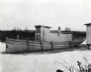
| Description: | View of a tug boat docked on frozen Lake Minnetonka. The boat was powered by an International PD-80 power unit and bears signage reading "Priscilla" and ".... |
| Date: | 1939 |
|---|---|
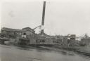
| Description: | A view from water of the Thunder Lake Lumber Co., one of the largest sawmills in Rhinelander. It was located on Lake Creek and operated until 1937. |
| Date: | 1939 |
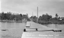
|---|---|
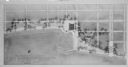
| Description: | View down long wooden dock. There is a diving board on the dock as well as ladders for people swimming. On shore are three parked automobiles and a few cab... |
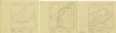
| Date: | 1939 |
|---|---|
| Description: | A survey map of Island Lake in Bayfield County, Wisconsin, Chain Lake in Rusk and Chippewa counties, and Manson Lake in Oneida County. The maps show the de... |

| Date: | 1939 |
|---|---|
| Description: | This map shows the towns to Gingles, Sanborn, and Guney as well as Chequamegon Bay, Kakagon River, White River, Marengo River, Bad River, Potato River, Vau... |

| Date: | 1939 |
|---|---|
| Description: | Label submitted to the state of Wisconsin for trademark registration. "Superfine Marathon Beer, Marathon City Brewing Company." In the foreground of the im... |

| Date: | 1939 |
|---|---|
| Description: | This nine-part map from the U.S. Bureau of Public Roads identifies federal and state highways in Wisconsin by pavement type. County, forest, park, and publ... |

| Date: | 1939 |
|---|---|
| Description: | This map of Sauk County, Wisconsin, shows the township and range grid, towns, sections, cities and villages, roads, railroads, lakes and rivers, schools, a... |

| Date: | 1939 |
|---|---|
| Description: | This 1939 map of Barron County, Wisconsin, shows the township and range grid, sections, cities and villages, and lakes and streams in the county. It lacks ... |

| Date: | 1939 |
|---|---|
| Description: | This map of Walworth County, Wisconsin, shows the township and range grid, sections, cities and town, and lakes and streams in the county. It lacks the key... |

| Date: | 1939 |
|---|---|
| Description: | This map of Walworth County, Wisconsin, shows the lakes and streams flowing into the Fox River and the lakes and streams flowing into the Rock River. The d... |

| Date: | 1939 |
|---|---|
| Description: | This 1939 map of Saint Croix County, Wisconsin, shows the township and range grid, cities and villages, and lakes and streams. |
| Date: | 1939 |
|---|---|
| Description: | A brochure for the Wisconsin Transportation Co. includes a map of Lake Geneva with towns and shoreline property owners identified. Black Point, on the sout... |

| Date: | 1939 |
|---|---|
| Description: | This brochure was intended for tourists and shows resorts, lakes and railroads in northwestern Wisconsin and part of Michigan’s upper peninsula. Also inclu... |
If you didn't find the material you searched for, our Library Reference Staff can help.
Call our reference desk at 608-264-6535 or email us at:
