 Filter: Categories of Wisconsin Historical Images
Filter: FULL_DATE of 1939
Filter: Subject of forests and forestry
Filter: Categories of Wisconsin Historical Images
Filter: FULL_DATE of 1939
Filter: Subject of forests and forestry

| Date: | 1939 |
|---|---|
| Description: | A color, pictorial map. Scale: 10 miles to the inch. Shows state parks and forests, proposed state parkways, proposed state monuments and memorials, nation... |

| Date: | 1939 |
|---|---|
| Description: | A pushes a large log with an International TD-40 TracTracTor (crawler tractor). Original caption reads: "TD-40 working at logging operations in Australia." |
| Date: | 1939 |
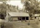
|---|---|
| Description: | The shelter house at Copper Falls State Park. |
| Date: | 1939 |
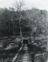
|---|---|
| Description: | View of a railroad track leading to the opening of a mine shaft. Logs or felled trees are lying on either side of the opening. |

| Date: | 1939 |
|---|---|
| Description: | This nine-part map from the U.S. Bureau of Public Roads identifies federal and state highways in Wisconsin by pavement type. County, forest, park, and publ... |

| Date: | 1939 |
|---|---|
| Description: | This illustrated map shows counties, highways, rivers, roads, present and proposed state parks and forests, proposed state parkways, proposed state monumen... |

| Date: | 1939 |
|---|---|
| Description: | An unidentified man is standing on a boulder on the beach looking out at Lake Michigan. |
If you didn't find the material you searched for, our Library Reference Staff can help.
Call our reference desk at 608-264-6535 or email us at: