 Filter: Categories of Wisconsin Historical Images
Filter: FULL_DATE of 1936
Filter: Categories of Wisconsin Historical Images
Filter: FULL_DATE of 1936

| Date: | 1936 |
|---|---|
| Description: | Clay mock-up of front end for 1937 D-30 1 1/2 ton. |

| Date: | 1936 |
|---|---|
| Description: | Clay mock-up of 1937 front end for D-30 1 1/2 ton. |

| Date: | 1936 |
|---|---|
| Description: | Clay mock-up of front end of D-30 1 1/2 ton. |

| Date: | 1936 |
|---|---|
| Description: | Clay mock-up of 1937 front end for D-30 1 1/2 ton. |

| Date: | 1936 |
|---|---|
| Description: | Front end view of a clay mock-up styling study for a 1937 D-30 1 1/2 ton. |

| Date: | 1936 |
|---|---|
| Description: | Color coded map in pink, yellow, blue, and brown of Milwaukee County State and County trunk highways. The map includes a legend of symbols: "STEAM RAIL ROA... |

| Date: | 1936 |
|---|---|
| Description: | Spencer Tracy and Jeanette MacDonald standing and holding hands in a scene from the film San Francisco. They are looking off to the right. MacDonald... |

| Date: | 1936 |
|---|---|
| Description: | This map shows campsites, trails, auto roads, surrounding townships, and points of interest, by including pictorial illustrations. Includes an inserted map... |

| Date: | 1936 |
|---|---|
| Description: | Hans V. Kaltenborn, wearing a helmet, interviews one of Generalissimo Franco's commanders during the siege of Madrid. They are surrounded by young soldiers... |

| Date: | 1936 |
|---|---|
| Description: | This road map shows the major roads, cities, lakes, and rivers of Wisconsin and parts of the neighboring states and Canada, as well as advertisements for t... |

| Date: | 1936 |
|---|---|
| Description: | This map shows road surfaces, construction, flying fields, seaplane landings, populations of cities and towns, and ferry routes of Wisconsin and some of th... |
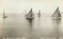
| Date: | 1936 |
|---|---|
| Description: | Elevated view across water towards small sailboats with two-man crews in Lake Michigan. A tree-lined shoreline is on the far right. |

| Date: | 1936 |
|---|---|
| Description: | This colored road map shows automobile roads in Wisconsin as well as portions of Michigan, Iowa, Minnesota, and Illinois. U.S. numbered highways are shown ... |

| Date: | 1936 |
|---|---|
| Description: | This colored road map shows automobile roads in Wisconsin as well as portions of nearby states. U.S. numbered highways are shown in red, and information ab... |

| Date: | 1936 |
|---|---|
| Description: | This colored road map shows automobile roads in Wisconsin as well as portions of nearby states. Information on the quality and type of any given road (pave... |

| Date: | 1936 |
|---|---|
| Description: | This colored road map shows automobile roads in Wisconsin as well as portions of nearby states. Information on the quality and type of any given road (pave... |

| Date: | 1936 |
|---|---|
| Description: | This colored road map shows automobile roads in Wisconsin as well as portions of nearby states. Information on the quality and type of any given road (pave... |
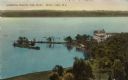
| Date: | 1936 |
|---|---|
| Description: | Elevated view of Lawsonia Country Club and strip of land jutting out into Green Lake. Caption reads: "Lawsonia Country Club Point, Green Lake, Wis." |

| Date: | 1936 |
|---|---|
| Description: | View of a central business district, with an I.G.A. Grocery Store, a filling station, a Dodge car dealer, and a tavern. Automobiles are parked at the curb.... |
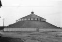
| Date: | 1936 |
|---|---|
| Description: | A large round barn, built as a show barn and arena, standing on the grounds of the Central Wisconsin State Fair. The barn has a band of clerestory windows ... |
If you didn't find the material you searched for, our Library Reference Staff can help.
Call our reference desk at 608-264-6535 or email us at: