 Filter: Categories of Wisconsin Historical Images
Filter: FULL_DATE of 1936
Filter: Subject of recreation areas
Filter: Categories of Wisconsin Historical Images
Filter: FULL_DATE of 1936
Filter: Subject of recreation areas

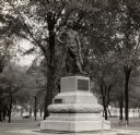
| Date: | 1936 |
|---|---|
| Description: | View of the Cushing Memorial monument, located in the vicinity of Delafield. |
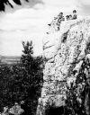
| Date: | 1936 |
|---|---|
| Description: | A rock outcropping with children at Rib Mountain State Park. |
| Date: | 1936 |
|---|---|
| Description: | Chief Oshkosh's statue and grave. Located in Menominee Park, formerly North Park. |
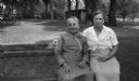
| Date: | 1936 |
|---|---|
| Description: | Two women sit on a bench in a park. Caption reads "Aunt Lydia with the photographer's wife Mary." |
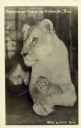
| Date: | 1936 |
|---|---|
| Description: | Mother lion cradling her cub at the Vilas Park Zoo (Henry Vilas Zoo). Caption reads: "Madonna and Child at the Madison, Wis., Zoo." |
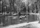
| Date: | 1936 |
|---|---|
| Description: | A view of the Marathon County Park. Many children are playing in the water surrounding a stone fountain, while others watch from the benches. |
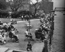
| Date: | 1936 |
|---|---|
| Description: | Elevated view of people in a park along the shoreline waiting for the White Bass run. |

| Date: | 1936 |
|---|---|
| Description: | View across lawn of Chequamegon National Forest Guard Station sign in front of one-story guard station building with two front doors. |

| Date: | 1936 |
|---|---|
| Description: | View of tents, benches, cars and trees at the camping grounds at Gogebic Park. |

| Date: | 1936 |
|---|---|
| Description: | This map of Neenah and Menasha shows some parks, churches, convention halls, and other buildings. These points of interest are in red ink. Streets, Little ... |

| Date: | 1936 |
|---|---|
| Description: | Street map of the City of Milwaukee and surrounding suburbs indicating various mass transit lines. There is an index to Milwaukee streets at the right of t... |

| Date: | 1936 |
|---|---|
| Description: | Color coded map in pink, yellow, blue, and brown of Milwaukee County State and County trunk highways. The map includes a legend of symbols: "STEAM RAIL ROA... |

| Date: | 1936 |
|---|---|
| Description: | This map shows campsites, trails, auto roads, surrounding townships, and points of interest, by including pictorial illustrations. Includes an inserted map... |

| Date: | 1936 |
|---|---|
| Description: | This colored road map shows automobile roads in Wisconsin as well as portions of Michigan, Iowa, Minnesota, and Illinois. U.S. numbered highways are shown ... |

| Date: | 1936 |
|---|---|
| Description: | Two smiling men, one carrying long fishing poles and the other a set of paddles, are walking away from their campsites while two women are working at a pic... |
If you didn't find the material you searched for, our Library Reference Staff can help.
Call our reference desk at 608-264-6535 or email us at: