 Filter: Categories of Wisconsin Historical Images
Filter: FULL_DATE of 1936
Filter: Subject of monuments
Filter: Categories of Wisconsin Historical Images
Filter: FULL_DATE of 1936
Filter: Subject of monuments
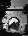
| Date: | 1936 |
|---|---|
| Description: | Camp Randall Memorial Arch with a gated path. |

| Date: | 1936 |
|---|---|
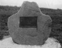
| Description: | View of the Cushing Memorial monument, located in the vicinity of Delafield. |
| Date: | 1936 |
|---|---|
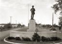
| Description: | View of a boulevard containing a Spanish war memorial statue. The plaque on the statue's base reads: "Memorial to those who served in the war with Spain, 1... |
| Date: | 1936 |
|---|---|
| Description: | A monument marking the Treaty of the Cedars. |
| Date: | 1936 |
|---|---|
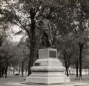
| Description: | Chief Oshkosh's statue and grave. Located in Menominee Park, formerly North Park. |
| Date: | 1936 |
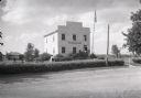
|---|---|
| Description: | Exterior view from across road of the first Wisconsin territorial Capitol building, as restored, in Old Belmont (later changed to Leslie). |

| Date: | 1936 |
|---|---|
| Description: | This colored road map shows automobile roads in Wisconsin as well as portions of Michigan, Iowa, Minnesota, and Illinois. U.S. numbered highways are shown ... |

| Date: | 1936 |
|---|---|
| Description: | This colored road map shows automobile roads in Wisconsin as well as portions of nearby states. Information on the quality and type of any given road (pave... |
If you didn't find the material you searched for, our Library Reference Staff can help.
Call our reference desk at 608-264-6535 or email us at: