 Filter: Categories of Wisconsin Historical Images
Filter: FULL_DATE of 1936
Filter: Subject of mississippi river
Filter: Categories of Wisconsin Historical Images
Filter: FULL_DATE of 1936
Filter: Subject of mississippi river

| Date: | 1936 |
|---|---|
| Description: | Elevated view over the long roof of the Diamond Jo warehouse. The Mississippi River is on the left, with hills in the background. |

| Date: | 1936 |
|---|---|
| Description: | This 1936 Wisconsin Conservation Dept. map shows the locations of state forestry Civilian Conservation Corps (CCC) camps, closed state forestry CCC camps, ... |

| Date: | 1936 |
|---|---|
| Description: | Four men are building the wall at Signal Point Lookout in Wyalusing State Park. They are part of Works Progress Administration (WPA) Project #8656-8. Th... |

| Date: | 1936 |
|---|---|
| Description: | This map shows the state trunk highway system and county trunk highways. This map show surface type on state and county trunk highways and the locations of... |
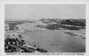
| Date: | 1936 |
|---|---|
| Description: | Text on front reads: "Trempealeau Wis. on the Great River Road overlooking Lock & Dam No. 6 on the Upper Mississippi." On reverse: "Lock & Dam No. 6, one o... |
If you didn't find the material you searched for, our Library Reference Staff can help.
Call our reference desk at 608-264-6535 or email us at: