 Filter: Categories of Wisconsin Historical Images
Filter: FULL_DATE of 1936
Filter: Subject of human settlements
Filter: Categories of Wisconsin Historical Images
Filter: FULL_DATE of 1936
Filter: Subject of human settlements

| Date: | 1936 |
|---|---|
| Description: | This map of Neenah and Menasha shows some parks, churches, convention halls, and other buildings. These points of interest are in red ink. Streets, Little ... |

| Date: | 1936 |
|---|---|
| Description: | Street map of the City of Milwaukee and surrounding suburbs indicating various mass transit lines. There is an index to Milwaukee streets at the right of t... |
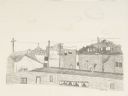
| Date: | 1936 |
|---|---|
| Description: | Original lithograph of a view over the forms of rooftops. Title on bottom right reads: "S.F. Beach Scene." |

| Date: | 1936 |
|---|---|
| Description: | View from street towards the St. Joseph's Hospital. In the center is a two level open porch, with two people on the second level. A 1930s automobile is par... |

| Date: | 1936 |
|---|---|
| Description: | Winter scene with a gas powered shovel being used to move snow from a snow-covered road. A man is standing in the road to the right, watching. The shovel i... |

| Date: | 1936 |
|---|---|
| Description: | This map shows the state trunk highway system and county trunk highways. This map show surface type on state and county trunk highways and the locations of... |

| Date: | 1936 |
|---|---|
| Description: | Color coded map in pink, yellow, blue, and brown of Milwaukee County State and County trunk highways. The map includes a legend of symbols: "STEAM RAIL ROA... |

| Date: | 1936 |
|---|---|
| Description: | This map shows campsites, trails, auto roads, surrounding townships, and points of interest, by including pictorial illustrations. Includes an inserted map... |

| Date: | 1936 |
|---|---|
| Description: | This road map shows the major roads, cities, lakes, and rivers of Wisconsin and parts of the neighboring states and Canada, as well as advertisements for t... |

| Date: | 1936 |
|---|---|
| Description: | This map shows road surfaces, construction, flying fields, seaplane landings, populations of cities and towns, and ferry routes of Wisconsin and some of th... |

| Date: | 1936 |
|---|---|
| Description: | This colored road map shows automobile roads in Wisconsin as well as portions of Michigan, Iowa, Minnesota, and Illinois. U.S. numbered highways are shown ... |

| Date: | 1936 |
|---|---|
| Description: | This colored road map shows automobile roads in Wisconsin as well as portions of nearby states. U.S. numbered highways are shown in red, and information ab... |

| Date: | 1936 |
|---|---|
| Description: | View of a central business district, with an I.G.A. Grocery Store, a filling station, a Dodge car dealer, and a tavern. Automobiles are parked at the curb.... |
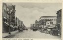
| Date: | 1936 |
|---|---|
| Description: | View of a central business district street lined with lampposts and electric signs. Automobiles are parked at the curbs. Caption reads: "Main Street Lookin... |

| Date: | 1936 |
|---|---|
| Description: | Raymond (Ray) Griesemer is sitting on his Harley-Davidson motorcycle. He is wearing a jacket, dark pants and boots. In the background is a field with grass... |
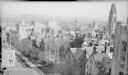
| Date: | 1936 |
|---|---|
| Description: | An elevated view of the Old Campus area of Yale University, with Chapel Street crossing diagonally at lower left. There is a partial view of Bingham Hall a... |

| Date: | 1936 |
|---|---|
| Description: | Caption on back reads: "Gov. Parks. Colony day 1936. Ruth Dearmond behind him (right)." There is a child standing in the foreground, and many people are ga... |

| Date: | 1936 |
|---|---|
| Description: | View from Langdon Street towards the front of the Wisconsin Historical Society. Vines cover the stone balustrade and trees are in the foreground. |

| Date: | 1936 |
|---|---|
| Description: | A uniformed police officer stands in an intersection and holds his hand out in the direction of several children. Cars are in the background. Caption reads... |

| Date: | 1936 |
|---|---|
| Description: | Poster in English, French, German and Spanish. Includes text in four languages, and images of children and war damage. |
If you didn't find the material you searched for, our Library Reference Staff can help.
Call our reference desk at 608-264-6535 or email us at: