 Filter: Categories of Wisconsin Historical Images
Filter: FULL_DATE of 1935
Filter: Subject of forests and forestry
Filter: Categories of Wisconsin Historical Images
Filter: FULL_DATE of 1935
Filter: Subject of forests and forestry
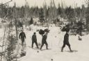
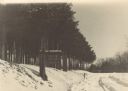
| Date: | 1935 |
|---|---|
| Description: | Winter scene with four men walking on snowshoes through a forest. |
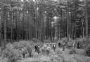
| Date: | 1935 |
|---|---|
| Description: | Slightly elevated view of a ribes eradication crew that was part of the white pine blister rust effort in a Barron County forest. The caption indicates tha... |
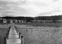
| Date: | 1935 |
|---|---|
| Description: | Barracks buildings at the Crystal Lake Civilian Conservation Corps (CCC) camp. |

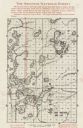
| Date: | 1935 |
|---|---|
| Description: | This map shows Wisconsin’s pinery region. Lake Superior, Lake Michigan, Lake Winnebago, Green Bay, the Wisconsin River, and the Mississippi River are label... |

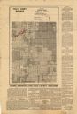
| Date: | 1935 |
|---|---|
| Description: | This map shows in different colors virgin timberland, second growth timber, pasture belt, crop-pasture belt, intensive crop-pasture belt, intensive pasture... |

| Date: | 1935 |
|---|---|
| Description: | This three-part map from the U.S. Bureau of Public Roads identifies highways in Wisconsin that have been improved, indicating those which are federal highw... |

| Date: | 1935 |
|---|---|
| Description: | "Drott's conservation guide" map shows the locations of Indian reservations, parks, fish hatcheries, forests, lookout towers, Wisconsin Conservations Commi... |

| Date: | 1935 |
|---|---|
| Description: | This pictorial map of northern Bayfield County, Wisconsin, shows the Chequamegon National Forest, the Red Cliff Indian Reservation, highways and roads, and... |
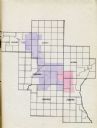
| Date: | 1935 |
|---|---|
| Description: | Map of a portion of Central Wisconsin with areas zoned for reforestation. The area is divided into two sites which are shaded in purple and red. |

| Date: | 1935 |
|---|---|
| Description: | Map of Juneau County showing area zoned for reforestation shaded in red. |
| Date: | 1935 |
|---|---|
| Description: | View down snowy road through a forest improvement area in Wyalusing State Park. There is a truck in the background, and a sign on the left side of the road... |

| Date: | 1935 |
|---|---|
| Description: | The Works Progress Administration (WPA) used Civilian Conservation Corps (CCC) to build a stone fireplace and landscape an area in Wyalusing State Park (fo... |

| Date: | 1935 |
|---|---|
| Description: | This is WPA (Works Progress Administration) project #8656 of a log and masonry picnic table built by the CCC (Civilian Conservation Corps) at Wyalusing Sta... |
| Date: | 1935 |
|---|---|
| Description: | This map shows land zoning. The top middle includes a key of land zones, forestry, recreation, and unrestricted. The map includes extensive text on zoning ... |

| Date: | 1935 |
|---|---|
| Description: | This map shows rivers, lakes, communities, woods, fishing locations, and vacation destinations. The back of the map includes text about agricultural, sceni... |
| Date: | 1935 |
|---|---|
| Description: | This map shows land for sale by the company in northwestern part of Nicolet National Forest. The map also shows shoreline acreages, railroads, roads, trail... |
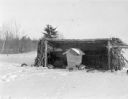
| Date: | 1935 |
|---|---|
| Description: | A flock of grouse are feeding from a wooden feeder which is protected by a rough, three sided log shelter with a shed roof and walls of corn stalks. A desc... |
| Date: | 1935 |
|---|---|
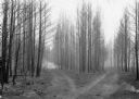
| Description: | Two logging roads diverge in a stand of burned jack pine trees, dividing the scene into three parts. In the background, near the left branch of the road, t... |

| Date: | 1935 |
|---|---|
| Description: | View across lawn towards two men sitting on a log bench in the central open area of the shelter house at Council Grounds State Forest (now Council Grounds ... |

| Date: | 1935 |
|---|---|
| Description: | View across water towards an unidentified man sitting in the stern of a small boat, holding a fishing rod. A younger man, sitting forward, is rowing. There... |
If you didn't find the material you searched for, our Library Reference Staff can help.
Call our reference desk at 608-264-6535 or email us at: